


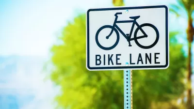
Not all bicycle infrastructure is created equal. Dallas planners are working to find new ways to build protected bike lanes instead of sharrows and other half-measures.
Brandon Formby reports on efforts in the city of Dallas to build out bicycle infrastructure. The key statistics: "In 2012, Dallas had 8 miles of on-street bike lanes. Today that’s grown to 39.3 miles. Within the next few years, that’s expected to increase to 107 miles."
Formby notes, however, some residents, "including some Dallas City Council members, aren’t as awed. That’s largely because 32 miles of the network so far is made up of shared lanes. Those are places where the city paints arrows and bike icons often called 'sharrows' to indicate cyclists and drivers share the same space."
The rest of the article goes on to detail the challenges facing the city in its efforts to build a more complete, protected network. Included with those challenges, however, is good news for bicyclists, such as the city's draft complete streets design manual.
FULL STORY: Dallas bike lanes moving forward, but not the way everyone wants

Houston Mayor Promises Dedicated Austin Street Bike Lane After Public Backlash
Although the one-way bike lane won’t be protected by physical barriers, the proposal is an improvement over the mayor’s initial plan to only include sharrows on the Austin Street project.
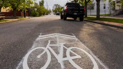
Calls to Stop Relying on Sharrows Grow Louder
The painted symbols can not only fail to protect bike riders, but can actually make riding conditions less safe.
How Sharrows Became Cycling’s Most Hated Symbol
Originally designed as a low-cost way to encourage safer road sharing between bikes and cars, the sharrow has become a symbol of the lack of commitment to protected bike infrastructure in many cities.

Maui's Vacation Rental Debate Turns Ugly
Verbal attacks, misinformation campaigns and fistfights plague a high-stakes debate to convert thousands of vacation rentals into long-term housing.

Planetizen Federal Action Tracker
A weekly monitor of how Trump’s orders and actions are impacting planners and planning in America.

In Urban Planning, AI Prompting Could be the New Design Thinking
Creativity has long been key to great urban design. What if we see AI as our new creative partner?

Florida Seniors Face Rising Homelessness Risk
High housing costs are pushing more seniors, many of them on a fixed income, into homelessness.

Massachusetts Budget Helps Close MBTA Budget Gap
The budget signed by Gov. Maura Healey includes $470 million in MBTA funding for the next fiscal year.

Milwaukee Launches Vision Zero Plan
Seven years after the city signed its Complete Streets Policy, the city is doubling down on its efforts to eliminate traffic deaths.
Urban Design for Planners 1: Software Tools
This six-course series explores essential urban design concepts using open source software and equips planners with the tools they need to participate fully in the urban design process.
Planning for Universal Design
Learn the tools for implementing Universal Design in planning regulations.
Gallatin County Department of Planning & Community Development
Heyer Gruel & Associates PA
JM Goldson LLC
City of Camden Redevelopment Agency
City of Astoria
Transportation Research & Education Center (TREC) at Portland State University
Jefferson Parish Government
Camden Redevelopment Agency
City of Claremont