


A recent trend in returning the use of streets and other public space to the use of humans and other modes of transportation other than the car is more striking with some historical perspective.
A recent trend in returning the use of streets and other public space to the use of humans and other modes of transportation other than the car is more striking with some historical perspective.
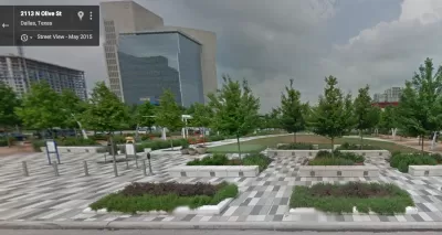
Melia Robinson shares 41 examples of public space makeovers around the world—curated by a Brazilian urban planning collective called Urb-i. The team at Urb-I scoured Google Street View, for examples of public spaces remade for humans, rather than cars. Examples from the United States include Klyde Warren Park in Dallas, Times Square in New York City, a "People St." in the Silver Lake neighborhood of Los Angeles, Atwater Street in Detroit, and Coenties Slip and Dutch Kills Green in New York City.
Robinson shares 41 examples, but the Urb-I team has produced more than 300 public space transformations from around the world.
FULL STORY: 41 amazing public space transformations captured by Google Street View

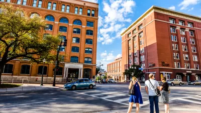
A New Vision for Dallas’ Dealey Plaza
After decades of neglect, a team of designers reimagines the infamous plaza as a safe, vibrant, multimodal public space.
Rethinking Streets During the Pandemic
A new book from the "Rethinking Streets" series identifies 25 quick redesigns cities can use to reconfigure streets for the realities of the COVID-19 pandemic.
Pedestrian-Friendly Makeover of a Busy Toronto Street Stops Short of the Car-Free Ideal
The yongeTOmorrrow project is heading toward the finish line with widespread support from advocates, but a few want the plan to go one step further.

Maui's Vacation Rental Debate Turns Ugly
Verbal attacks, misinformation campaigns and fistfights plague a high-stakes debate to convert thousands of vacation rentals into long-term housing.

Planetizen Federal Action Tracker
A weekly monitor of how Trump’s orders and actions are impacting planners and planning in America.

In Urban Planning, AI Prompting Could be the New Design Thinking
Creativity has long been key to great urban design. What if we see AI as our new creative partner?

Portland Raises Parking Fees to Pay for Street Maintenance
The city is struggling to bridge a massive budget gap at the Bureau of Transportation, which largely depleted its reserves during the Civd-19 pandemic.

Spokane Mayor Introduces Housing Reforms Package
Mayor Lisa Brown’s proposals include deferring or waiving some development fees to encourage more affordable housing development.

Houston Mayor Kills Another Bike Lane
The mayor rejected a proposed bike lane in the Montrose district in keeping with his pledge to maintain car lanes.
Urban Design for Planners 1: Software Tools
This six-course series explores essential urban design concepts using open source software and equips planners with the tools they need to participate fully in the urban design process.
Planning for Universal Design
Learn the tools for implementing Universal Design in planning regulations.
Gallatin County Department of Planning & Community Development
Heyer Gruel & Associates PA
JM Goldson LLC
City of Camden Redevelopment Agency
City of Astoria
Transportation Research & Education Center (TREC) at Portland State University
Jefferson Parish Government
Camden Redevelopment Agency
City of Claremont