The nationwide trend of cities, counties, and regions adopting complete streets policies continued its momentum in 2014. A new report from the National Complete Streets Coalition surveys the field and decides which is the best of the best.

The terms "good, better, and best" are often used to describe planning and design alternatives. Complete streets policies provide some of the clearest examples of how the powers that be choose from this spectrum in enacting changes to the built environment of their communities. And considering that over 70 jurisdictions adopted complete streets policies in 2014, down only slightly from over 80 plans in 2013, it's an appropriate time to pause and think critically about the trend.
That's all well and good, but how many of these complete streets plans are actually great?
A new report by Smart Growth America's National Complete Streets Coalition assumes that not all complete streets policies are created equal, as cities, counties, and regions rush to create complete streets policies to satisfy the desires of a broadening coalition of citizen, business, and environmental interests asking for changes to the status quo of street design.
Released this morning, the "Best Complete Streets Policies of 2014" [pdf] evaluates all 74 policies approved in 2014 by communities in the United States on ten criteria that reflect the platform of the National Complete Streets Coalition.
You wanted to know who the best is? The report scored the following ten jurisdictions highest for the policies adopted in 2014:
1. Ogdensburg, NY
2. Troy, NY
3. Lakemoor, IL (tie)
3. Dawson County, MT (tie)
3. Austin, TX (tie)
6. Acton, MA (tie)
6. Middleton, MA (tie)
6. Reading, MA (tie)
6. Salem, MA (tie)
10. Los Angeles County Metropolitan Transportation Authority (tie)
10. Stoughton, MA (tie)
"We celebrate the best policies because they do the most to help people," said Roger Millar, director of the National Complete Streets Coalition, in a press release announcing the report. "Great policy language can make streets safer for someone walking with a child or more convenient for a person in a wheelchair."
For those of you keeping track at home, Littleton, Massachusetts took the top spot in the 2013 report.
In an important note, the report finds a general trend of improvement in this year's policies compared to past, earlier iterations of this relatively new trend in planning practice. Hopefully, setting high standards and celebrating the best of the best will continue to inspire the highest quality of work.
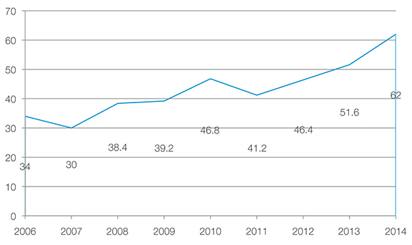
In addition to the rankings, the report includes other data that places the new policies in context. For instance, since 1971, small suburbs have adopted far more complete streets policies than jurisdictions of larger size.
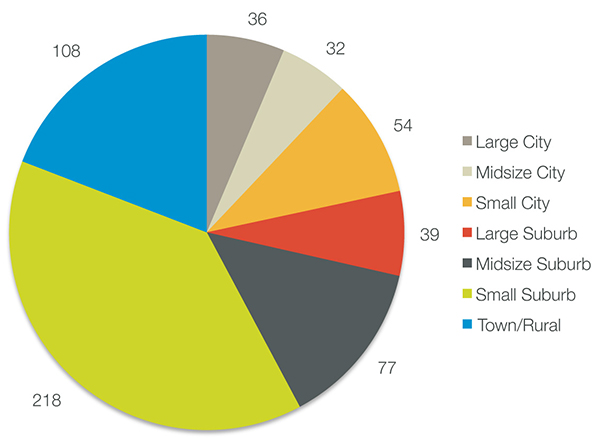
So with these examples of best practices as a guide, we say godspeed (but 20 is plenty) to all you planners, designers, and policy makers putting the finishes touches on complete streets plans in 2015.

Maui's Vacation Rental Debate Turns Ugly
Verbal attacks, misinformation campaigns and fistfights plague a high-stakes debate to convert thousands of vacation rentals into long-term housing.

Planetizen Federal Action Tracker
A weekly monitor of how Trump’s orders and actions are impacting planners and planning in America.

In Urban Planning, AI Prompting Could be the New Design Thinking
Creativity has long been key to great urban design. What if we see AI as our new creative partner?

Cal Fire Chatbot Fails to Answer Basic Questions
An AI chatbot designed to provide information about wildfires can’t answer questions about evacuation orders, among other problems.

What Happens if Trump Kills Section 8?
The Trump admin aims to slash federal rental aid by nearly half and shift distribution to states. Experts warn this could spike homelessness and destabilize communities nationwide.

Sean Duffy Targets Rainbow Crosswalks in Road Safety Efforts
Despite evidence that colorful crosswalks actually improve intersection safety — and the lack of almost any crosswalks at all on the nation’s most dangerous arterial roads — U.S. Transportation Secretary Duffy is calling on states to remove them.
Urban Design for Planners 1: Software Tools
This six-course series explores essential urban design concepts using open source software and equips planners with the tools they need to participate fully in the urban design process.
Planning for Universal Design
Learn the tools for implementing Universal Design in planning regulations.
Appalachian Highlands Housing Partners
Gallatin County Department of Planning & Community Development
Heyer Gruel & Associates PA
Mpact (founded as Rail~Volution)
City of Camden Redevelopment Agency
City of Astoria
City of Portland
City of Laramie


