


Denver’s Equity Atlas is a pioneering effort between private, public, and non-profit interests to visualize a variety of statistics for the Denver metro area.
According to Mijin Cha of the National Equity Atlas, the Denver Equity Atlas is "an online interactive tool that creates custom maps and summaries of statistics for particular interest areas in the region. The online tool was launched in partnership between Mile High Connects and the Denver Regional Council of Governments, the regional planning office. A Housing and Urban Development (HUD) Sustainable Communities Initiative Grant allowed the planning office and Mile High Connects to deepen their relationship and have joint ownership over the Atlas."
The Mile High Connects group, a creator of the original Equity Atlas tool, sees it as their most important tool within their box. Mile High Connects uses the toolbox to spur new relationships with many more interested organizations.
By overlaying information on education, income, health, and other equity metrics, the Denver Equity Atlas helped fight for better transportation access. For example, advocates used the tool to show the dependence of low income communities on a certain bus route slated for closing due to the opening of the city’s new light rail system.
FULL STORY: Denver's Equity Atlas: Improving Urban Planning With Equity Data

A National Model for Transit Equity
Kaid Benfield looks at a groundbreaking new report compiled by Reconnecting America and the equity coalition Mile High Connects, that suggests how the expansion of Denver's transit system could reach traditionally underserved populations.
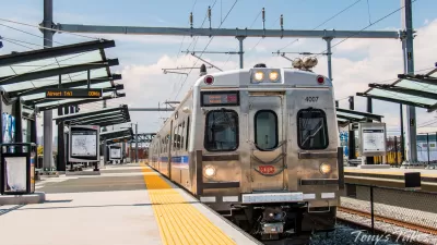
Denver-Area Rail Service Disruptions Expected During Maintenance Work
RTD is beginning maintenance on retaining walls along its southeastern light rail lines that is expected to last roughly six months.
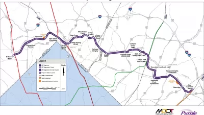
New Tool Demystifies Regulations Around Maryland's Purple Line
The tool aims to help stakeholders "cut through regulatory complexity" and ensure equitable access to the light rail line's economic benefits.

Maui's Vacation Rental Debate Turns Ugly
Verbal attacks, misinformation campaigns and fistfights plague a high-stakes debate to convert thousands of vacation rentals into long-term housing.

Planetizen Federal Action Tracker
A weekly monitor of how Trump’s orders and actions are impacting planners and planning in America.

In Urban Planning, AI Prompting Could be the New Design Thinking
Creativity has long been key to great urban design. What if we see AI as our new creative partner?

Portland Raises Parking Fees to Pay for Street Maintenance
The city is struggling to bridge a massive budget gap at the Bureau of Transportation, which largely depleted its reserves during the Civd-19 pandemic.

Spokane Mayor Introduces Housing Reforms Package
Mayor Lisa Brown’s proposals include deferring or waiving some development fees to encourage more affordable housing development.

Houston Mayor Kills Another Bike Lane
The mayor rejected a proposed bike lane in the Montrose district in keeping with his pledge to maintain car lanes.
Urban Design for Planners 1: Software Tools
This six-course series explores essential urban design concepts using open source software and equips planners with the tools they need to participate fully in the urban design process.
Planning for Universal Design
Learn the tools for implementing Universal Design in planning regulations.
Gallatin County Department of Planning & Community Development
Heyer Gruel & Associates PA
JM Goldson LLC
City of Camden Redevelopment Agency
City of Astoria
Transportation Research & Education Center (TREC) at Portland State University
Jefferson Parish Government
Camden Redevelopment Agency
City of Claremont