


The tool aims to help stakeholders "cut through regulatory complexity" and ensure equitable access to the light rail line's economic benefits.
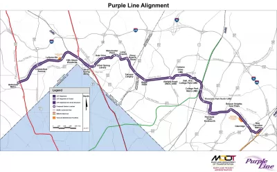
A new tool from the University of Maryland’s National Center for Smart Growth Research and Education (NCSG) "provides easy access to a curated database of plans and regulations" in the Purple Line corridor, the area surrounding Maryland's upcoming Purple Line light rail. Cyrus Chimento, who worked on the project, writes in Greater Greater Washington that while the Purple Line project "presents massive benefits to locals such as increasing transportation access, decreasing pollution, and creating jobs," not all residents will share the benefits. "To combat this potential outcome, the Purple Line Corridor Coalition (PLCC) formed a community development agreement among businesses, nonprofits, government agencies, and community groups to make sure the Purple Line benefits are shared equitably among all residents and workers in the area." The coalition's goals include supporting and growing local businesses, improving access to housing choices, and building a thriving labor market.
The Plans and Regulations Information Tool aims to simplify the navigation of the area's complex regulatory environment. "The real power of the tool is to (very quickly) answer the general question underpinning those mentioned above: 'What plans or regulations apply to this place?' And since the Purple Line corridor spans multiple jurisdictions, we bring all the data together in one place." The tool is designed to assist developers and other interested stakeholders in understanding local regulations, and its designers hope "it can be a piece of the larger effort to make sure the benefits of the Purple Line investment accrue equitably."
FULL STORY: This tool helps create equitable development in communities surrounding the Purple Line


DC Metro Is Betting on Buses
The agency plans to significantly expand bus service, which can be added faster and at a lower cost than rail projects.
DC Suburban Light Rail Expansion Prompts Mixed-Use Development
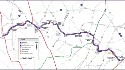
The Purple Line’s expansion into Maryland suburbs in 2027 has spurred TOD along the line.
Coalition Fights Displacement Along Purple Line
Community advocates are warning that Maryland’s new light rail line could cause displacement without concerted efforts to preserve affordable housing and legacy businesses.

Planetizen Federal Action Tracker
A weekly monitor of how Trump’s orders and actions are impacting planners and planning in America.

Chicago’s Ghost Rails
Just beneath the surface of the modern city lie the remnants of its expansive early 20th-century streetcar system.

San Antonio and Austin are Fusing Into one Massive Megaregion
The region spanning the two central Texas cities is growing fast, posing challenges for local infrastructure and water supplies.

Since Zion's Shuttles Went Electric “The Smog is Gone”
Visitors to Zion National Park can enjoy the canyon via the nation’s first fully electric park shuttle system.

Trump Distributing DOT Safety Funds at 1/10 Rate of Biden
Funds for Safe Streets and other transportation safety and equity programs are being held up by administrative reviews and conflicts with the Trump administration’s priorities.

German Cities Subsidize Taxis for Women Amid Wave of Violence
Free or low-cost taxi rides can help women navigate cities more safely, but critics say the programs don't address the root causes of violence against women.
Urban Design for Planners 1: Software Tools
This six-course series explores essential urban design concepts using open source software and equips planners with the tools they need to participate fully in the urban design process.
Planning for Universal Design
Learn the tools for implementing Universal Design in planning regulations.
planning NEXT
Appalachian Highlands Housing Partners
Mpact (founded as Rail~Volution)
City of Camden Redevelopment Agency
City of Astoria
City of Portland
City of Laramie