


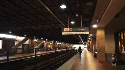
After a ballot measure approved the Metropolitan Atlanta Rapid Transit Authority's (MARTA) expansion into a suburban county outside of Atlanta, the transit agency could set precedent on how to effectively adapt to sprawling suburbs.
In a 1971 referendum, Clayton County (an adjacent county south of Atlanta that houses the city's enormous airport) rejected MARTA's service, as its white residents feared the transit system would make it easier for blacks to reach their suburbs. However, four decades later, with Clayton County's bus service collapsing, 74 percent of the county's diverse, largely working-class voters approved a measure to join MARTA and pay for the service with a new sales tax.
As discussed on The Week by Jacob Anbinder, MARTA is the only transit agency in the country that does not receive state-government funding. Despite a growing population in the last four years, between 2010 to 2013, the agency saw a 6,000-person decline in transit commuters, the most of any American city.
Moreover, Atlanta's commuting patterns are not the typical hub-and-spoke style. Anbiner discusses how, "Atlantans need to go from suburb to suburb more than they need to go downtown. Four in five Clayton commuters work somewhere other than Atlanta; at the same time, four in five people who work in Clayton County don't live there. Like Atlanta's aptly named Perimeter Center Mall, the new center of MARTA's network may well be at the perimeter."
FULL STORY: How public transportation can adapt to suburban sprawl


MARTA Scales Back Expansion Plans
Atlanta’s transit agency is slowing its plans to extend its bus and rail lines, prompting criticism from city officials.
Atlanta Transit Plans Stall Due to Budget Concerns
With MARTA facing a potential billion dollar shortfall, the agency says it can’t fulfill its system expansion plan.

Commuter Rail From Clayton County to Atlanta Planned by MARTA
The Atlanta region could soon gain a commuter rail line similar to those found in New York, Chicago, and Los Angeles.

Planetizen Federal Action Tracker
A weekly monitor of how Trump’s orders and actions are impacting planners and planning in America.

Restaurant Patios Were a Pandemic Win — Why Were They so Hard to Keep?
Social distancing requirements and changes in travel patterns prompted cities to pilot new uses for street and sidewalk space. Then it got complicated.

Maui's Vacation Rental Debate Turns Ugly
Verbal attacks, misinformation campaigns and fistfights plague a high-stakes debate to convert thousands of vacation rentals into long-term housing.

In California Battle of Housing vs. Environment, Housing Just Won
A new state law significantly limits the power of CEQA, an environmental review law that served as a powerful tool for blocking new development.

Boulder Eliminates Parking Minimums Citywide
Officials estimate the cost of building a single underground parking space at up to $100,000.

Orange County, Florida Adopts Largest US “Sprawl Repair” Code
The ‘Orange Code’ seeks to rectify decades of sprawl-inducing, car-oriented development.
Urban Design for Planners 1: Software Tools
This six-course series explores essential urban design concepts using open source software and equips planners with the tools they need to participate fully in the urban design process.
Planning for Universal Design
Learn the tools for implementing Universal Design in planning regulations.
Heyer Gruel & Associates PA
JM Goldson LLC
Custer County Colorado
City of Camden Redevelopment Agency
City of Astoria
Transportation Research & Education Center (TREC) at Portland State University
Camden Redevelopment Agency
City of Claremont
Municipality of Princeton (NJ)