


Americans tend to pay more attention to wind strength than storm surge when evaluating whether or not to evacuate before a hurricane. A new NOAA mapping project is designed to change perceptions about the multiple risks of storm events.
The National Oceanic and Atmospheric Administration (NOAA) will begin mapping coastal regions in varying hues to represent the danger represented by storm surge, according to a recent article by Barbara Liston.
Recent polls determined the Americans tend to consider wind strength above storm surge when considering evacuation—a mistake that proved costly during Hurricane Sandy in 2012 and Hurricane Ike in 2008.
The new maps are intended to provide residents of coastal areas a clearer understanding of the multiple risks posed by Hurricanes. Forty-eight hours prior to the landfall of a hurricane, the NOAA will begin releasing color-coded maps indicating the risk of flooding, updating them every six hours.
FULL STORY: New hurricane forecast maps to show flood risk from storm surge

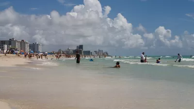
Miami Beach: A Four-Foot High Barrier Island Awaited Irma
A city of almost 92,000 people sits on a one-mile wide island designed by nature to protect the mainland from ocean swells, storms, and hurricanes. The seven-mile long island, which floods even when sunny, was spared from catastrophic storm surge.
Hurricane Ian Puts Renewed Focus on Florida's Barrier Islands
Ian did not impact Southeast Florida, but coastal residents there took notice of the state's deadliest hurricane since 1935 that devastated much of Southwest Florida last month, particularly the barrier islands off the Gulf Coast.
As Development in Flood-Prone Areas Continues, Cities Are Slow to Respond
Drawn by affordable property, low taxes, and job opportunities, high numbers of Americans continue to move to flood-prone areas even as the threat of catastrophic flooding grows.

Planetizen Federal Action Tracker
A weekly monitor of how Trump’s orders and actions are impacting planners and planning in America.

Restaurant Patios Were a Pandemic Win — Why Were They so Hard to Keep?
Social distancing requirements and changes in travel patterns prompted cities to pilot new uses for street and sidewalk space. Then it got complicated.

Map: Where Senate Republicans Want to Sell Your Public Lands
For public land advocates, the Senate Republicans’ proposal to sell millions of acres of public land in the West is “the biggest fight of their careers.”

Orange County, Florida Adopts Largest US “Sprawl Repair” Code
The ‘Orange Code’ seeks to rectify decades of sprawl-inducing, car-oriented development.

Maui's Vacation Rental Debate Turns Ugly
Verbal attacks, misinformation campaigns and fistfights plague a high-stakes debate to convert thousands of vacation rentals into long-term housing.

San Francisco Suspends Traffic Calming Amidst Record Deaths
Citing “a challenging fiscal landscape,” the city will cease the program on the heels of 42 traffic deaths, including 24 pedestrians.
Urban Design for Planners 1: Software Tools
This six-course series explores essential urban design concepts using open source software and equips planners with the tools they need to participate fully in the urban design process.
Planning for Universal Design
Learn the tools for implementing Universal Design in planning regulations.
Heyer Gruel & Associates PA
JM Goldson LLC
Custer County Colorado
City of Camden Redevelopment Agency
City of Astoria
Transportation Research & Education Center (TREC) at Portland State University
Camden Redevelopment Agency
City of Claremont
Municipality of Princeton (NJ)