


San Diego's downtown street grid features smaller blocks than almost all other major U.S. cities. Small blocks mean more intersections, less distance between them, and a lot of interrupted bipedaling. Bill Adams reviews some potential fixes.
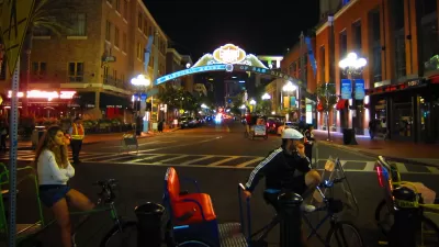
Walking from point A to point B in downtown San Diego, whether for exercise or for a more utilitarian purpose, can be a frustrating experience, notes San Diego land use attorney and downtown denizen Bill Adams.
"San Diego’s downtown street grid and its small blocks make continuous walking difficult, especially for people trying to go in a straight line. Jogging is even more difficult. The blocks are 200 by 300 feet. Among major cities, only Portland has smaller blocks at 200 by 200 feet. So depending on walking direction, pedestrians generally must stop every 200 or 300 feet to wait for traffic. . ."
"Today, the uniform small blocks and 75 foot wide one-way roads maximize the automobile’s domain and undermine the walkability of downtown. The problem is made even worse by San Diego’s $100 plus jaywalking tickets (about twice that of a parking ticket – another pro-auto bias?)."
However, small blocks and many intersections don't need to need to mean interrupted walking, notes Adams citing Portland. He reviews some of the methods tried elsewhere for suitability in San Diego, from shared space to pedestrian only streets.
FULL STORY: Why Downtown San Diego Pedestrians Stop for Cars More Than Any Other City and What to do About it.

Report: Walking Rates Down in All US States
While walking trips decline, driving is back to near-pre-pandemic levels.
How Sidewalks Literally Sideline the Pedestrian
Plenty of sidewalks stand in need of improvement, and many aren't there at all. But they're also a symbol of the automobile's engineered dominance of our roads.
San Diego Satellite Town Asks: Smart Growth or Trojan Horse?
San Diego County's "most walkable city" is being challenged to identify the real smart growth: what it has or what is being proposed. At issue: a plan amendment for a high density project near transit. But is the project real?

Planetizen Federal Action Tracker
A weekly monitor of how Trump’s orders and actions are impacting planners and planning in America.

Maui's Vacation Rental Debate Turns Ugly
Verbal attacks, misinformation campaigns and fistfights plague a high-stakes debate to convert thousands of vacation rentals into long-term housing.

San Francisco Suspends Traffic Calming Amidst Record Deaths
Citing “a challenging fiscal landscape,” the city will cease the program on the heels of 42 traffic deaths, including 24 pedestrians.

Amtrak Rolls Out New Orleans to Alabama “Mardi Gras” Train
The new service will operate morning and evening departures between Mobile and New Orleans.

The Subversive Car-Free Guide to Trump's Great American Road Trip
Car-free ways to access Chicagoland’s best tourist attractions.

San Antonio and Austin are Fusing Into one Massive Megaregion
The region spanning the two central Texas cities is growing fast, posing challenges for local infrastructure and water supplies.
Urban Design for Planners 1: Software Tools
This six-course series explores essential urban design concepts using open source software and equips planners with the tools they need to participate fully in the urban design process.
Planning for Universal Design
Learn the tools for implementing Universal Design in planning regulations.
Heyer Gruel & Associates PA
JM Goldson LLC
Custer County Colorado
City of Camden Redevelopment Agency
City of Astoria
Transportation Research & Education Center (TREC) at Portland State University
Jefferson Parish Government
Camden Redevelopment Agency
City of Claremont