


People-powered street design is getting a major boost with the help of two new tools that make it easy to reimagine unsatisfactory streetscapes.
Streetmix has some competition.
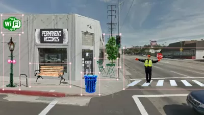
The first platform, presented by Alissa Walker, is Blockee, another Code for America product. "Blockee is really easy to use," she explains. "Just type in an address to generate a Google Street View image (or upload your own photo), and using the blissfully simple editor, drag and drop everything from vegetable gardens to food trucks to bike share kiosks into the street. Once you share your creation, the site even offers tips for how to make your vision a reality."
In Fast Company, Ben Schiller looks at Key to the Street, "a new citizen-planning tool" developed by Jessica Lowry. "Using your phone, it lets you take a photograph of a site, and immediately start sketching and filling in features. You can then share your concept with the city government, and allow others to riff on your ideas."
"Lowry is planning a pilot with Austin next January," notes Schiller. "Volunteers will use the tool to make diaries of what it's like to travel the city's public transit, and generate suggestions for improvements. A full version of Key to the Street should be available for other cities next March."
FULL STORY: This Awesome App Helps You Add "Civic Bling" to Your Street

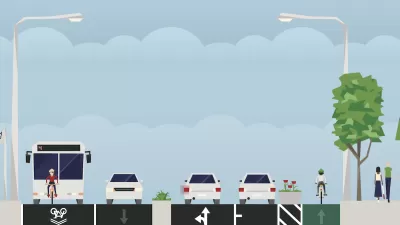
Streetmix Socializes Street Design
OK, so we missed this relaunch for our just-published list of the Top Websites. Another remarkable venture from the fellows at civic tech leader Code for America, Streeetmix is an impressively user-friendly and attractive tool for designing streets.
Reimagining Your Street
How to use free online tools to redesign your local streetscape.
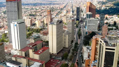
Bogotá Uses 7,000 Public Design Proposals to Redesign its Main Artery
To reimagine the city's most important artery, Bogotá sought community input via an innovative online platform.

Planetizen Federal Action Tracker
A weekly monitor of how Trump’s orders and actions are impacting planners and planning in America.

San Francisco's School District Spent $105M To Build Affordable Housing for Teachers — And That's Just the Beginning
SFUSD joins a growing list of school districts using their land holdings to address housing affordability challenges faced by their own employees.

The Tiny, Adorable $7,000 Car Turning Japan Onto EVs
The single seat Mibot charges from a regular plug as quickly as an iPad, and is about half the price of an average EV.

As Trump Phases Out FEMA, Is It Time to Flee the Floodplains?
With less federal funding available for disaster relief efforts, the need to relocate at-risk communities is more urgent than ever.

With Protected Lanes, 460% More People Commute by Bike
For those needing more ammo, more data proving what we already knew is here.

In More Metros Than You’d Think, Suburbs are Now More Expensive Than the City
If you're moving to the burbs to save on square footage, data shows you should think again.
Urban Design for Planners 1: Software Tools
This six-course series explores essential urban design concepts using open source software and equips planners with the tools they need to participate fully in the urban design process.
Planning for Universal Design
Learn the tools for implementing Universal Design in planning regulations.
Smith Gee Studio
City of Charlotte
City of Camden Redevelopment Agency
City of Astoria
Transportation Research & Education Center (TREC) at Portland State University
US High Speed Rail Association
City of Camden Redevelopment Agency
Municipality of Princeton (NJ)