


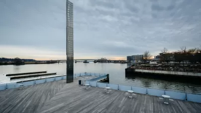
Does D.C. want to be a swamp? Are waterfronts for tow parks or people? Heidi Petersen reports on a panel discussion on the past and future of Washington's waterfront at the National Building Museum.

Remembering the industrial past of riverfronts, a discussion panel of planning professionals, gathered at the National Building Museum in Washington, D.C. in June to discuss building along rivers, brought up the salient question: "Is the waterfront a back door or a front door?"
With a focus on recreational development along the Potomac and Anacostia Rivers, the panel concluded that riverfronts are important to both commerce and recreational activity.
Part of the discussion focused on the bureaucratic hurdles that must be jumped in order to implement any significant change for which there is great demand, such as non-motorized recreational boating on the D.C. waterfront. The discussion also meandered to the river as a "double-edged sword," both helping and hindering development with the potential for flooding, particularly in Prince George's County, home to the infamous "rain tax" on impervious surfaces.
The Yards, a new park on the Potomac in Georgetown, has become very popular with the public, an example of the riverfront being used as front door, above the flood zone, of course.
FULL STORY: Is your waterfront a back door or a front door

Want to Swim in the Potomac? Army Corps to Study the Possibility
The U.S. Army Corps of Engineers could soon study how to legalize swimming in the rivers around the nation’s capital—a scenario that would have seemed impossible in the not-too-distant past.
Coming Soon to D.C.: Rivers Clean Enough for Swimming
A tremendous open space and recreation addition could be on the horizon for residents of Washington, D.C., but there's still work to do in cleaning the Potomac and Anacostia rivers.
Will Narrow Focus Sink Plans to Clean D.C.'s Polluted Waters?
A 20-year, $2.6 billion Clean Rivers Project intended to eliminate sewage discharge into D.C. area waterways will benefit the entire region. So, Carol O’Cleireacain asks, why only stick Washington's residents with the bill?

Planetizen Federal Action Tracker
A weekly monitor of how Trump’s orders and actions are impacting planners and planning in America.

Map: Where Senate Republicans Want to Sell Your Public Lands
For public land advocates, the Senate Republicans’ proposal to sell millions of acres of public land in the West is “the biggest fight of their careers.”

Restaurant Patios Were a Pandemic Win — Why Were They so Hard to Keep?
Social distancing requirements and changes in travel patterns prompted cities to pilot new uses for street and sidewalk space. Then it got complicated.

Platform Pilsner: Vancouver Transit Agency Releases... a Beer?
TransLink will receive a portion of every sale of the four-pack.

Toronto Weighs Cheaper Transit, Parking Hikes for Major Events
Special event rates would take effect during large festivals, sports games and concerts to ‘discourage driving, manage congestion and free up space for transit.”

Berlin to Consider Car-Free Zone Larger Than Manhattan
The area bound by the 22-mile Ringbahn would still allow 12 uses of a private automobile per year per person, and several other exemptions.
Urban Design for Planners 1: Software Tools
This six-course series explores essential urban design concepts using open source software and equips planners with the tools they need to participate fully in the urban design process.
Planning for Universal Design
Learn the tools for implementing Universal Design in planning regulations.
Heyer Gruel & Associates PA
JM Goldson LLC
Custer County Colorado
City of Camden Redevelopment Agency
City of Astoria
Transportation Research & Education Center (TREC) at Portland State University
Camden Redevelopment Agency
City of Claremont
Municipality of Princeton (NJ)