Where you build is important. But when it comes to city budgets, how much you build matters more.
There is a wonderful new report [link] released by Smart Growth America that everyone should read. The report has many wonderful findings that uphold what we’ve always believed: smart growth pays for itself. And then some. The report also reiterates that sprawl is not only wasteful to land consumption but also to tax dollars.
Here’s a key quote: “Decisions about where to build will have implications for one-third of a typical municipality’s budget.”
No one can argue this. It makes too much sense. A core element of smart growth is locating future development in ways that avoid sensitive lands and protects primary resources while taking advantage of the synergy brought on by clustered urban patterns. The clustering really matters to city budgets.
But Smart Growth can be a hard political fight. We can’t always achieve the ideal scenario. Thus, it’s important to know what matters the most—or rather, what elements of Smart Growth can have the most benefit to city budgets.
Consider my town. Columbia, Tennessee. The Smart Growth report illustrates why Columbia should encourage new development that, at minimum, pays for itself. This basically means that we should avoid sprawling outward and turn inward to invest our resources in places that can offer an expedient return.
But what if—and believe me … this is a hypothetical—but what if Columbia received a request for a 500 acre New Urbanist community five miles from the City’s downtown? One of those high-density, neotraditional enclaves built in a greenfield, faraway from our police headquarters, fire station, and/or sanitation department? Would such a development be bad for city budgets? Would it be “dumb growth” rather than “smart growth”?
In terms of its impact on city budgets, the development would be smart growth. Yes, the project would occur far away from the core but the development itself is practically guaranteed to be smart. Why? Because what matters most to city budgets isn’t so much the location of new development but the value.
City budgets aren’t affected so much by the location of development (the cost to serve) as much as they are affected by the value (the revenue the development returns). A new development could be miles away from the city’s service centers and it would be fine if the community generates property tax revenues that meet the cost for serving it.
I’ll talk more about this in a future article but, for now, my research with Columbia, Tennessee has yielded a startling—but perfectly sensible—conclusion:
The taxable value of development is what matters most to a city budget (very obvious).
Nothing equates to the taxable value of a property more than building intensity (not so obvious, perhaps?).
Indeed, building intensity is the most powerful dynamic of them all. What does the term mean? It refers to the degree by which a property maximizes its potential for development. So as you’ll see in my examples, a house on a one-acre lot is terrible for intensity. A condo is terrific.
This dynamic is directly enforced by two planning regulations: floor-area-ratio and lot coverage. Either of these measures can capture this relationship but floor-area-ratio is better. Indeed, for all the bad associations many of us have with F.A.R., it turns out to be the best predictor of cost-efficient development (i.e., development that provides a net gain to the City).
It’s also the factor that makes a strip commercial center more valuable than a Wal-Mart or a modest home more valuable than a palatial estate.
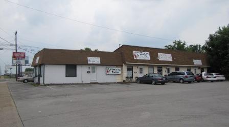
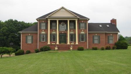
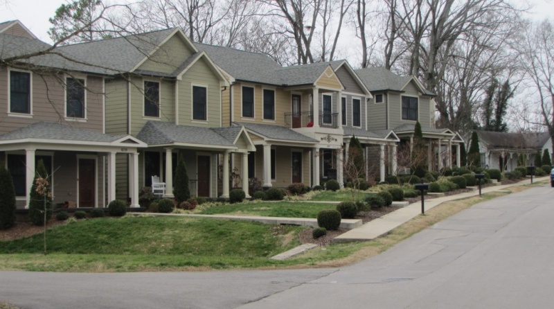
Here are some simple examples from Columbia, Tennessee:
This is the town's Wal-Mart. Its value per acre is $658,191 and its FAR is 0.2.
This is an aging strip center worth $852,904 per acre, $200,000 more than the Wal-Mart; it has an FAR of 0.44.

This estate home is worth $131,551 per acre and has an FAR of 0.03.

This cluster of individually-platted homes average, individually, to $2,158,398 per acre with an FAR of 1.2.

In each case, the best development for a city budget is determined not by lot size, building size, location, or aesthetics. Those are secondary. The primary factor is how much structure is built on the lot. In fact, when I analyzed the most cost-efficient developments in our city, sorted by residential and non-residential, I came across an awesome statistic.
As shown in the scattergraph below, the correlation between cost-efficient development and building intensity is an incredible 0.87! (A perfect correlation is expressed as 1.) No other measurable element (e.g. lot size, building height, date of construction, density, use type) comes even remotely close.
For my analysis, cost-efficient development is any development that meets a certain value threshold that provides a net gain to our city budget. In this case, I set the threshold at $16 of assessed value per square foot for commercial and $12 assessed value for residential. Building intensity is simply floor-area-ratio.
The most cost-efficient development is scattered all over Columbia. Some of it is located at the core, some of it at the edge, and all points in-between. Their only true common trait is building intensity. As the floor-area-ratio increased, so too did the value and the revenue brought back to the budget.
Here’s a crucial point: rules that regulate building intensity (such as F.A.R. or minimum lot coverage) are our best tool for ensuring cost-efficient development. It’s the most reliable correlation I’ve ever seen. It’s not about property values. No matter how beautiful a place is, or how close it is to the city core, such elements do not help the city if they waste space.
This should serve as a mild defense for those greenfield communities built on the edge of your town. From a budget standpoint, they are immensely better than any first-ring suburb of half-acre tracts. But I hope this research also serves a practical application. For all the critiques over F.A.R. and lot coverage requirements, these two rules do more than anything else to ensure that development balances a city budget. I’ll write more on this in future posts. In the meantime, here are a couple things to remember:
- Smart Growth is important. We should practice it as best we can. But in many cases, a city cannot achieve perfection; when these situations arise, go for intensity. Intense developments can be so valuable, even on the edge, that they pay for themselves and provide a net gain.
- We should all consider a minimum building intensity to ensure cost-efficient development (while also reducing wasteful land consumption). What is the right standard? It depends but, in Columbia, the most reliable characteristic amongst such development was 60% lot coverage or 0.6 FAR. If every store and house achieved this minimum, our budget would be quite impressive.
But the key isn’t to have impressive budgets; the key is to create a resilient city. And building intensity helps that, too. I’ll share more on that next week.
Author's Note: I’d like to thank Rick Bernhardt, FAICP and Jennifer Carlat, AICP for reviewing the work and offering advice. Special thanks to Paul Keltner, AICP for his vital assistance in the research.

Planetizen Federal Action Tracker
A weekly monitor of how Trump’s orders and actions are impacting planners and planning in America.

Maui's Vacation Rental Debate Turns Ugly
Verbal attacks, misinformation campaigns and fistfights plague a high-stakes debate to convert thousands of vacation rentals into long-term housing.

San Francisco Suspends Traffic Calming Amidst Record Deaths
Citing “a challenging fiscal landscape,” the city will cease the program on the heels of 42 traffic deaths, including 24 pedestrians.

Amtrak Rolls Out New Orleans to Alabama “Mardi Gras” Train
The new service will operate morning and evening departures between Mobile and New Orleans.

The Subversive Car-Free Guide to Trump's Great American Road Trip
Car-free ways to access Chicagoland’s best tourist attractions.

San Antonio and Austin are Fusing Into one Massive Megaregion
The region spanning the two central Texas cities is growing fast, posing challenges for local infrastructure and water supplies.
Urban Design for Planners 1: Software Tools
This six-course series explores essential urban design concepts using open source software and equips planners with the tools they need to participate fully in the urban design process.
Planning for Universal Design
Learn the tools for implementing Universal Design in planning regulations.
Heyer Gruel & Associates PA
JM Goldson LLC
Custer County Colorado
City of Camden Redevelopment Agency
City of Astoria
Transportation Research & Education Center (TREC) at Portland State University
Jefferson Parish Government
Camden Redevelopment Agency
City of Claremont


