


They're among the most populous cities in the world. So why are India's largest cities virtually bereft of skylines? Mark Bergen explores the answers.
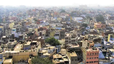
Bergen reports from Bangalore, a city more populous than New York or Hong Kong, where one of the tallest buildings is only 420 feet.
"Cities in China and southeast Asia rise high, but Indian ones did not. Most grew like Bangalore: outwards and compact. Their skylines are almost nonexistent. And their urban ills -- millions without housing, millions more facing exorbitant rents and crumbling infrastructure -- are often given the economic prescription to grow up."
"It leads to a natural question: Why aren't Indian cities that tall? But there are others who pose a very different query: Why should they be?"
Limits on the availability of resources like electricity and water form a natural deterrent to vertical construction. "But the culprit for most Indian cities is the tight rein on building codes," explains Bergen. "The floor-area-ratio in Bangalore, up to 3.25 but around 1.25 in many areas, requires builders to pay for pricey land plots if they want to build up. (In a recent midtown rezoning, Manhattan proposed FARs as high as 24)."
Despite an institutional bias towards sprawl and low-rise housing, "some cities are now looking up. Recently, the national urban development minister urged New Delhi to permit more skyscrapers, and Gurgaon, a booming city in its periphery, floated an increased FAR. Bangalore, too, is seeing a slew of lofty, vertical projects."
FULL STORY: Why India Keeps Its Cities So Short

Will Upzoning Destroy the Beaux Arts Legacy of Midtown Manhattan?
A development proposal for a 1,450 glass skyscraper adjacent to Grand Central Station prompted the Architectural Record to wonder whether New York is chipping away the "Beaux Arts heart" of Manhattan.
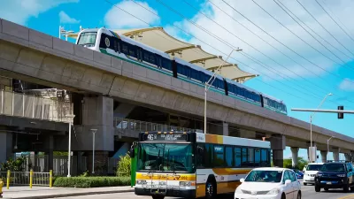
Honolulu Skyline Train Enters Final Construction Phase
The third phase of the project will expand service to downtown Honolulu on the ‘nation’s first large-scale, publicly run automated metro system.’
NYC Budget Makes Key Building Code Change
The change could spur more housing development if accompanying reforms in the City of Yes for Housing Opportunity plan are approved.

Planetizen Federal Action Tracker
A weekly monitor of how Trump’s orders and actions are impacting planners and planning in America.

Map: Where Senate Republicans Want to Sell Your Public Lands
For public land advocates, the Senate Republicans’ proposal to sell millions of acres of public land in the West is “the biggest fight of their careers.”

Restaurant Patios Were a Pandemic Win — Why Were They so Hard to Keep?
Social distancing requirements and changes in travel patterns prompted cities to pilot new uses for street and sidewalk space. Then it got complicated.

Platform Pilsner: Vancouver Transit Agency Releases... a Beer?
TransLink will receive a portion of every sale of the four-pack.

Toronto Weighs Cheaper Transit, Parking Hikes for Major Events
Special event rates would take effect during large festivals, sports games and concerts to ‘discourage driving, manage congestion and free up space for transit.”

Berlin to Consider Car-Free Zone Larger Than Manhattan
The area bound by the 22-mile Ringbahn would still allow 12 uses of a private automobile per year per person, and several other exemptions.
Urban Design for Planners 1: Software Tools
This six-course series explores essential urban design concepts using open source software and equips planners with the tools they need to participate fully in the urban design process.
Planning for Universal Design
Learn the tools for implementing Universal Design in planning regulations.
Heyer Gruel & Associates PA
JM Goldson LLC
Custer County Colorado
City of Camden Redevelopment Agency
City of Astoria
Transportation Research & Education Center (TREC) at Portland State University
Camden Redevelopment Agency
City of Claremont
Municipality of Princeton (NJ)