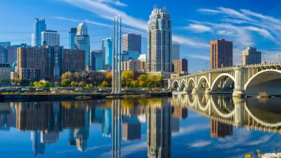
Could the nascent plan for Gateway Park satiate Minneapolitans suffering from downtown park envy?
The benefits of a signature park located in downtown Minneapolis to civic pride, attracting young professionals, and economic development are clear, writes Marlys Harris. Besides, "[a]ll the very best cities have one." The most promising prospect is being championed by Minneapolis civic and business leaders involved in the Trust for Public Land, who since 2008 have "been jonesing for a major park in the city's core."
"The plan that has evolved is Gateway Park," says Harris, "which would stretch from 5th Street to the Mississippi. In a way, it's more a green corridor with lots of trees lining Hennepin and Nicollet to hook up two major splotches of actual park. The first would unite Cancer Survivors Park between Second and Third Streets with a now-empty lot next to the Main Library... Two triangles of land fronting Hennepin would provide passageways to a second large patch on Hennepin and First Street that would terrace down to the waterfront below."
According to Harris, "[p]ractically everybody in town has signed on to the plan: the Minneapolis Downtown Council, the mayor, the steering committee which includes leaders from Target, Piper Jaffray, the Pohlad Family Companies, the Minneapolis Planning Commission and the Parks and Recreation Board."
However obstacles remain. "The main problem may be that no official government body seems to 'own' the project. The Downtown Council and the Trust for Public Land are its 'champions,' says [Bruce Chamberlain, assistant superintendant for planning services for Park and Recreation]. But the Park Board sees Gateway as an adjunct to its own agenda to develop the riverfront from downtown to the city's northern border."
FULL STORY: Gateway Park: When will Minneapolis get a signature downtown park?

Planetizen Federal Action Tracker
A weekly monitor of how Trump’s orders and actions are impacting planners and planning in America.

Map: Where Senate Republicans Want to Sell Your Public Lands
For public land advocates, the Senate Republicans’ proposal to sell millions of acres of public land in the West is “the biggest fight of their careers.”

Restaurant Patios Were a Pandemic Win — Why Were They so Hard to Keep?
Social distancing requirements and changes in travel patterns prompted cities to pilot new uses for street and sidewalk space. Then it got complicated.

Maui's Vacation Rental Debate Turns Ugly
Verbal attacks, misinformation campaigns and fistfights plague a high-stakes debate to convert thousands of vacation rentals into long-term housing.

San Francisco Suspends Traffic Calming Amidst Record Deaths
Citing “a challenging fiscal landscape,” the city will cease the program on the heels of 42 traffic deaths, including 24 pedestrians.

California Homeless Arrests, Citations Spike After Ruling
An investigation reveals that anti-homeless actions increased up to 500% after Grants Pass v. Johnson — even in cities claiming no policy change.
Urban Design for Planners 1: Software Tools
This six-course series explores essential urban design concepts using open source software and equips planners with the tools they need to participate fully in the urban design process.
Planning for Universal Design
Learn the tools for implementing Universal Design in planning regulations.
Heyer Gruel & Associates PA
JM Goldson LLC
Custer County Colorado
City of Camden Redevelopment Agency
City of Astoria
Transportation Research & Education Center (TREC) at Portland State University
Camden Redevelopment Agency
City of Claremont
Municipality of Princeton (NJ)


