


The NYT chief art critic, Michael Kimmelman, reviews Madrid's almost complete six-mile long park, Madrid Rio, that is having a transformative effect on the city. The park was made possible by the under-grounding of the M-30 ring road.
Kimmelman adds Madrid Rio to the growing list of new urban spaces around the world made possible by taking down freeways, beginning with San Francisco's elevated Embarcadero Freeway in 1989. Unlike the San Francisco boulevard replacement, Madrid Mayor Alberto Ruíz-Gallardón chose a much more expensive alternative, costing $4.5 billion to tunnel the freeway. Madrid Rio also reclaims the Manzanares River-front.
"More than six miles long, it transforms a formerly neglected area in the middle of Spain's capital. Its creation, in four years, atop a complex network of tunnels dug to bury an intrusive highway, also rejuvenates a long-lost stretch of the Manzanares River, and in so doing knits together neighborhoods that the highway had cut off from the city center.
All around the world, highways are being torn down and waterfronts reclaimed; decades of thinking about cars and cities reversed; new public spaces created."
Madrid Rio includes more than just green space.
"(T)he park belongs to a larger transformation that includes the construction of dozens of new metro and light-rail stations that link far-flung, disconnected and often poor districts on Madrid's outskirts to downtown."
FULL STORY: In Madrid's Heart, Park Blooms Where a Freeway Once Blighted

Madrid Uses Transit System for Parcel Delivery to Cut Emissions
A new pilot program uses trains to deliver packages at off-peak hours, lowering emissions from trucks.
Madrid Has the Bike Infrastructure Model the U.S. Needs
A happy accident, Madrid may have stumbled onto a bike infrastructure program with great results. Only time will tell if "slow" lanes yield long-term positive results.
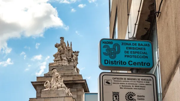
Driving Ban in Madrid Central Survives Despite Change of Leadership
In sharp contrast to France's yellow vest demonstrations against fuel tax hikes, Madrid residents took to the streets to keep them free of motor vehicles after new leaders were elected who vowed to rescind the driving ban enacted last November.

Maui's Vacation Rental Debate Turns Ugly
Verbal attacks, misinformation campaigns and fistfights plague a high-stakes debate to convert thousands of vacation rentals into long-term housing.

Planetizen Federal Action Tracker
A weekly monitor of how Trump’s orders and actions are impacting planners and planning in America.

In Urban Planning, AI Prompting Could be the New Design Thinking
Creativity has long been key to great urban design. What if we see AI as our new creative partner?

Massachusetts Budget Helps Close MBTA Budget Gap
The budget signed by Gov. Maura Healey includes $470 million in MBTA funding for the next fiscal year.

Milwaukee Launches Vision Zero Plan
Seven years after the city signed its Complete Streets Policy, the city is doubling down on its efforts to eliminate traffic deaths.

Portland Raises Parking Fees to Pay for Street Maintenance
The city is struggling to bridge a massive budget gap at the Bureau of Transportation, which largely depleted its reserves during the Civd-19 pandemic.
Urban Design for Planners 1: Software Tools
This six-course series explores essential urban design concepts using open source software and equips planners with the tools they need to participate fully in the urban design process.
Planning for Universal Design
Learn the tools for implementing Universal Design in planning regulations.
Gallatin County Department of Planning & Community Development
Heyer Gruel & Associates PA
JM Goldson LLC
City of Camden Redevelopment Agency
City of Astoria
Transportation Research & Education Center (TREC) at Portland State University
Jefferson Parish Government
Camden Redevelopment Agency
City of Claremont