


Google Maps searches include a pinpoint of what the search engine has determined are the centers of cities. One artist has built sculptures of those pinpoints in their real-life locations.
Titled "Map", the pinpoint sculptures are part of an installation by German artist Aram Bartholl.
"Starting in 2006, Bartholl created a series of six-meter tall sculptures of the iconic red marker used by Google Maps. The artist had recognized that the familiar 20-pixel graphic used by Google casts shadows on the widely consulted digital maps as if they were physical objects in real space. Likewise, when the map is switched to satellite mode, the virtual pins seem to become part of the city."
FULL STORY: Where is the Center of a City?

Seattle's Weirdest Intersections Make a Fetching Design
One artist capitalized on the quirks of Seattle's street grid.
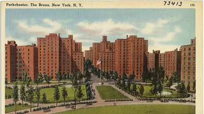
Affordable Living in The Bronx
A look at Parkchester, one of four planned communities built by the Metropolitan Life Insurance Company in New York City, circa 1940s. The complex includes over 12,000 rental and ownership apartments, located near the #6 subway.
A Never-Ending Map Of Imaginary Cities
Artist spends decades creating an always-growing hand-drawn paper map of an imaginary place. Development is determined by drawing a random card from a custom deck of cards.

Planetizen Federal Action Tracker
A weekly monitor of how Trump’s orders and actions are impacting planners and planning in America.

Maui's Vacation Rental Debate Turns Ugly
Verbal attacks, misinformation campaigns and fistfights plague a high-stakes debate to convert thousands of vacation rentals into long-term housing.

San Francisco Suspends Traffic Calming Amidst Record Deaths
Citing “a challenging fiscal landscape,” the city will cease the program on the heels of 42 traffic deaths, including 24 pedestrians.

Amtrak Rolls Out New Orleans to Alabama “Mardi Gras” Train
The new service will operate morning and evening departures between Mobile and New Orleans.

The Subversive Car-Free Guide to Trump's Great American Road Trip
Car-free ways to access Chicagoland’s best tourist attractions.

San Antonio and Austin are Fusing Into one Massive Megaregion
The region spanning the two central Texas cities is growing fast, posing challenges for local infrastructure and water supplies.
Urban Design for Planners 1: Software Tools
This six-course series explores essential urban design concepts using open source software and equips planners with the tools they need to participate fully in the urban design process.
Planning for Universal Design
Learn the tools for implementing Universal Design in planning regulations.
Heyer Gruel & Associates PA
JM Goldson LLC
Custer County Colorado
City of Camden Redevelopment Agency
City of Astoria
Transportation Research & Education Center (TREC) at Portland State University
Jefferson Parish Government
Camden Redevelopment Agency
City of Claremont