


Artist spends decades creating an always-growing hand-drawn paper map of an imaginary place. Development is determined by drawing a random card from a custom deck of cards.
Since 1963, Jerry Gretzinger has been drawing and painting an ever-growing paper map filled with imaginary cities, rivers, lakes, railroads, airports, highways, & farmlands. He uses a photocopier, pens, and paints and keeps track of the growing map's over 2600 "tiles" in a spreadsheet.
"Now Jerry uses a specially crafted deck of cards to determine the outcome of his world, with fictitious cities like “Plaeides,” “Wybourne” and the largest, “Ukrainia.” Each day he draws cards to see how a page of his gigantic map will be modified, with perhaps the most unusual card being the 'void.' With this card a blank spot is put on the map, wiping out previous details completely and opening up a world of new possibility. "
The map was on exhibit at the Massachusetts Museum of Contemporary Art in 2012. A zoomable version of the map is available online.
FULL STORY: VisualNews


Opinion: Enhancing Inclusive Development: The Crucial Role of the Creative Class in Urban Planning
How bringing local artists into the development process can foster more vibrant, equitable neighborhoods.

How the National Park Service Uses GIS
A new book demonstrates how the National Park Service uses GIS technology to meet its mission and showcases a selection of maps used for effectively managing national parks.
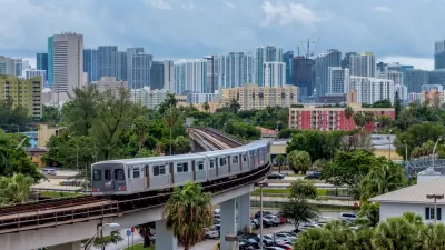
New Tool Puts Miami Development Opportunities on the Map
There's plenty of vacant or underutilized land to be found in Miami-Dade County, if you know where and how to look.

Planetizen Federal Action Tracker
A weekly monitor of how Trump’s orders and actions are impacting planners and planning in America.

Chicago’s Ghost Rails
Just beneath the surface of the modern city lie the remnants of its expansive early 20th-century streetcar system.

San Antonio and Austin are Fusing Into one Massive Megaregion
The region spanning the two central Texas cities is growing fast, posing challenges for local infrastructure and water supplies.

Since Zion's Shuttles Went Electric “The Smog is Gone”
Visitors to Zion National Park can enjoy the canyon via the nation’s first fully electric park shuttle system.

Trump Distributing DOT Safety Funds at 1/10 Rate of Biden
Funds for Safe Streets and other transportation safety and equity programs are being held up by administrative reviews and conflicts with the Trump administration’s priorities.

German Cities Subsidize Taxis for Women Amid Wave of Violence
Free or low-cost taxi rides can help women navigate cities more safely, but critics say the programs don't address the root causes of violence against women.
Urban Design for Planners 1: Software Tools
This six-course series explores essential urban design concepts using open source software and equips planners with the tools they need to participate fully in the urban design process.
Planning for Universal Design
Learn the tools for implementing Universal Design in planning regulations.
planning NEXT
Appalachian Highlands Housing Partners
Mpact (founded as Rail~Volution)
City of Camden Redevelopment Agency
City of Astoria
City of Portland
City of Laramie