


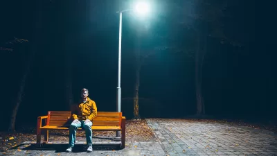
Urban design is increasingly linked with poor health conditions. Grist's Sarah Goodyear explains how cities are literally killing people.
Looking at a recent study of neighborhood-based incidences of diabetes in Toronto, Goodyear writes that a city's form can have major impacts on the health of its people.
"The thing is, even if you don't own an automobile, you live in a place that is built for them -- because by now, every place is. As the Toronto study and others in the United States have revealed, it's not just the autocentric suburban states in the so-called "Diabetes Belt" that have a problem. Residents of dense urban areas also suffer from high rates of obesity and diabetes, in part because of the lack of healthy food choices, in part because certain ethnic groups are more predisposed to diabetes, and in part because the streetscape is degraded and ignored. The problem is worst in parts of the city like New York's Southwest Bronx -- where neglected street infrastructure, pedestrian-unfriendly design, crime rates, and urban freeways make it unpleasant or unsafe to spend much time outside."
FULL STORY: Fat city: The way your neighborhood is built could be killing you


January Must-Reads: Top 10 Articles From Last Month
How a tidal wave of potential changes at the federal level could throw many programs planners depend on into chaos, a roundup of last year’s zoning stories, and the continuing ripple effects of a landmark Supreme Court case.
Can Urban Design Truly Impact Loneliness?
Some theorists want to design cities to reduce loneliness and isolation. Others want to accommodate them.
Fighting the ‘Loneliness Epidemic’ in Cities
While urban design alone can’t mend the tears in our social fabric, planning decisions and thoughtful, inclusive design can offer or hinder opportunities for interaction.

Planetizen Federal Action Tracker
A weekly monitor of how Trump’s orders and actions are impacting planners and planning in America.

Restaurant Patios Were a Pandemic Win — Why Were They so Hard to Keep?
Social distancing requirements and changes in travel patterns prompted cities to pilot new uses for street and sidewalk space. Then it got complicated.

Map: Where Senate Republicans Want to Sell Your Public Lands
For public land advocates, the Senate Republicans’ proposal to sell millions of acres of public land in the West is “the biggest fight of their careers.”

Maui's Vacation Rental Debate Turns Ugly
Verbal attacks, misinformation campaigns and fistfights plague a high-stakes debate to convert thousands of vacation rentals into long-term housing.

San Francisco Suspends Traffic Calming Amidst Record Deaths
Citing “a challenging fiscal landscape,” the city will cease the program on the heels of 42 traffic deaths, including 24 pedestrians.

California Homeless Arrests, Citations Spike After Ruling
An investigation reveals that anti-homeless actions increased up to 500% after Grants Pass v. Johnson — even in cities claiming no policy change.
Urban Design for Planners 1: Software Tools
This six-course series explores essential urban design concepts using open source software and equips planners with the tools they need to participate fully in the urban design process.
Planning for Universal Design
Learn the tools for implementing Universal Design in planning regulations.
Heyer Gruel & Associates PA
JM Goldson LLC
Custer County Colorado
City of Camden Redevelopment Agency
City of Astoria
Transportation Research & Education Center (TREC) at Portland State University
Camden Redevelopment Agency
City of Claremont
Municipality of Princeton (NJ)