


In this wide-ranging post for The Atlantic, the NRDC's Kaid Benfield explores some of the major trends playing out in urban and suburban America, and how the suburbs are less and less the dominant urban form in the market.
The suburbs and the assumptions that enabled them to grow are collapsing, according to Benfield.
"[I]n between, say, 1960 and 2000, many central cities were in severe decline, due to "white flight" and all sorts of perceived urban problems. But for some tragic exceptions like Detroit, that decline now has either slowed dramatically or reversed. In D.C., for example, the central city is growing again after 50 years of decline and ironically, a new concern of some is that "white flight" is now to the city, not away from it. New York, Philadelphia, Indianapolis, Houston, Austin, and San Antonio also grew. This is where the change is.
In addition, the distinction between "central city" and "suburb" is simply not what it once was. Inner-ring suburbs now are part of the central city in every way other than the arbitrary jurisdictional lines that mean little economically or environmentally. In his blog West North, my friend Payton Chung points out that the supposed "suburban" district of Friendship Heights Village, in Maryland but adjacent to the D.C. city limits, is 'the single most densely populated place in the entire country, with 79,556 residents per square mile. Even Manhattan only clocks in at 69,468 per square mile.'"
FULL STORY: How History Killed the Suburb

Is A Denser Urban World Inevitable?
Writing in Foreign Policy, Joel Kotkin argues that increasing urbanization and density are not inevitable realities.
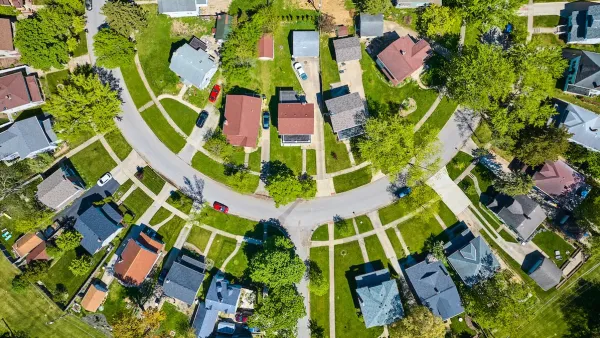
In More Metros Than You’d Think, Suburbs are Now More Expensive Than the City
If you're moving to the burbs to save on square footage, data shows you should think again.

Renters Now Outnumber Homeowners in Over 200 US Suburbs
High housing costs in city centers and the new-found flexibility offered by remote work are pushing more renters to suburban areas.

Maui's Vacation Rental Debate Turns Ugly
Verbal attacks, misinformation campaigns and fistfights plague a high-stakes debate to convert thousands of vacation rentals into long-term housing.

Planetizen Federal Action Tracker
A weekly monitor of how Trump’s orders and actions are impacting planners and planning in America.

San Francisco Suspends Traffic Calming Amidst Record Deaths
Citing “a challenging fiscal landscape,” the city will cease the program on the heels of 42 traffic deaths, including 24 pedestrians.

Adaptive Reuse Will Create Housing in a Suburban Texas Strip Mall
A developer is reimagining a strip mall property as a mixed-use complex with housing and retail.

Study: Anti-Homelessness Laws Don’t Work
Research shows that punitive measures that criminalized unhoused people don’t help reduce homelessness.

In U.S., Urban Gondolas Face Uphill Battle
Cities in Latin America and Europe have embraced aerial transitways — AKA gondolas — as sustainable, convenient urban transport, especially in tricky geographies. American cities have yet to catch up.
Urban Design for Planners 1: Software Tools
This six-course series explores essential urban design concepts using open source software and equips planners with the tools they need to participate fully in the urban design process.
Planning for Universal Design
Learn the tools for implementing Universal Design in planning regulations.
Heyer Gruel & Associates PA
JM Goldson LLC
Custer County Colorado
City of Camden Redevelopment Agency
City of Astoria
Transportation Research & Education Center (TREC) at Portland State University
Jefferson Parish Government
Camden Redevelopment Agency
City of Claremont