


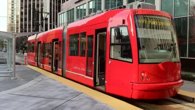
It was nearly 50 years ago, when streetcars were seen on the roadways of downtown Washington, DC. Dan Tangherlini, the former transportation director for the District discusses why streetcars matter in the United States capital.
Tangherlini says that one advantage streetcars have over buses is that the tracks "give a sense of permanence, and that encourages long-term investment." Portland, Ore., which started operating North America's first modern streetcar system in 2001, can attest to that. A 2008 study by the city says that since streetcar plans were unveiled in 1997, "$3.5 billion has been invested within two blocks of the streetcar alignment." The study lists "grocery stores, restaurants, galleries, shops and banks" as amenities that have been built near the streetcar lines.
Tangherlini emphasizes that economic development isn't merely a by-product of streetcar lines but, at least in D.C., part of the point of building the streetcar. He says when DDOT was planning the streetcar routes, it first mapped out current and future development, things like office buildings, shops and housing. The city is intentionally using streetcars to connect established activity centers, like Union Station, with emerging ones, like H Street in Northeast, which isn't connected to a Metrorail line but is trying to sustain new businesses and attract more visitors. Transportation isn't just for getting around, "it's for making places for people to go," says Tangherlini.
Thanks to Garrett Bradford
FULL STORY: The Case for Streetcars

Op-Ed: Streetcars Should Actually Serve Locals
While they're currently in vogue, streetcars are only worthwhile if they can be a viable option for local residents. Unfortunately, this is rarely how the systems are designed.
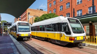
North Texas Transit Leaders Tout Benefits of TOD for Growing Region
At a summit focused on transit-oriented development, policymakers discussed how North Texas’ expanded light rail system can serve as a tool for economic growth.
DC Suburban Light Rail Expansion Prompts Mixed-Use Development
The Purple Line’s expansion into Maryland suburbs in 2027 has spurred TOD along the line.

Maui's Vacation Rental Debate Turns Ugly
Verbal attacks, misinformation campaigns and fistfights plague a high-stakes debate to convert thousands of vacation rentals into long-term housing.

Planetizen Federal Action Tracker
A weekly monitor of how Trump’s orders and actions are impacting planners and planning in America.

In Urban Planning, AI Prompting Could be the New Design Thinking
Creativity has long been key to great urban design. What if we see AI as our new creative partner?

King County Supportive Housing Program Offers Hope for Unhoused Residents
The county is taking a ‘Housing First’ approach that prioritizes getting people into housing, then offering wraparound supportive services.

Researchers Use AI to Get Clearer Picture of US Housing
Analysts are using artificial intelligence to supercharge their research by allowing them to comb through data faster. Though these AI tools can be error prone, they save time and housing researchers are optimistic about the future.

Making Shared Micromobility More Inclusive
Cities and shared mobility system operators can do more to include people with disabilities in planning and operations, per a new report.
Urban Design for Planners 1: Software Tools
This six-course series explores essential urban design concepts using open source software and equips planners with the tools they need to participate fully in the urban design process.
Planning for Universal Design
Learn the tools for implementing Universal Design in planning regulations.
planning NEXT
Appalachian Highlands Housing Partners
Mpact (founded as Rail~Volution)
City of Camden Redevelopment Agency
City of Astoria
City of Portland
City of Laramie