


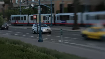
Three possibilities for tolling San Francisco's downtown have been advanced by the Board of Supervisors; two involve tolling the 'Southern Gateway', the only entrance to the peninsula city that is untolled. However, Prop 26 could doom the plan.
The plan centers on the Northeast 'Cordon' also, as it should since that section includes the congested downtown. Drivers who enter or leave from the city's southern border avoid the northern Golden Gate Bridge and northeastern Bay Bridge - both of which are tolled (the latter having congestion pricing) explaining the emphasis of the Southern Gateway in the scenarios.
The scenarios the supervisors will select from:
"-- Charge motorists $6 to leave the northeast sector between 3:30 and 6:30 p.m. ...
-- Charge $3 in each direction to cross San Francisco's southern border.....
- -Charge to cross the southern border and include an extra fee to park in private lots in the northeast sector during the peak commute times....."
From SF Weekly: Congestion Pricing Likely To Be Killed By Prop. 26: "The Chron did note that "The plan may need voters' support" -- and this may end up being the real story. While the paper doesn't mention Proposition 26, the just-passed measure could very well kill congestion pricing -- and any number of fees local governments use to balance the books."
Thanks to Paolo (Paul) Pezzotta, AICP
FULL STORY: S.F. may hit drivers with variety of tolls

Congestion Pricing Has Mayoral Support in San Francisco
Additional disincentives for driving (i.e., congestion pricing and new parking fees) are on the mayor's agenda in San Francisco.
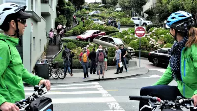
Social Equity Cited in Veto of California Road Pricing Bill
Gov. Gavin Newsom vetoed a unique road pricing bill due to concerns that charging a fee would limit access to driving on two blocks of Lombard Street, a popular tourist attraction in San Francisco that is severely congested.

Urban Congestion Pricing Might Finally Come to California
If Gov. Gavin Newsom signs legislation by San Francisco Assemblyman Phil Ting, motorists who want to drive the 'world's most crooked street,' a huge tourist draw, will be forced to participate in a pilot 'reservation and pricing program.'

Maui's Vacation Rental Debate Turns Ugly
Verbal attacks, misinformation campaigns and fistfights plague a high-stakes debate to convert thousands of vacation rentals into long-term housing.

Planetizen Federal Action Tracker
A weekly monitor of how Trump’s orders and actions are impacting planners and planning in America.

In Urban Planning, AI Prompting Could be the New Design Thinking
Creativity has long been key to great urban design. What if we see AI as our new creative partner?

Cal Fire Chatbot Fails to Answer Basic Questions
An AI chatbot designed to provide information about wildfires can’t answer questions about evacuation orders, among other problems.

What Happens if Trump Kills Section 8?
The Trump admin aims to slash federal rental aid by nearly half and shift distribution to states. Experts warn this could spike homelessness and destabilize communities nationwide.

Sean Duffy Targets Rainbow Crosswalks in Road Safety Efforts
Despite evidence that colorful crosswalks actually improve intersection safety — and the lack of almost any crosswalks at all on the nation’s most dangerous arterial roads — U.S. Transportation Secretary Duffy is calling on states to remove them.
Urban Design for Planners 1: Software Tools
This six-course series explores essential urban design concepts using open source software and equips planners with the tools they need to participate fully in the urban design process.
Planning for Universal Design
Learn the tools for implementing Universal Design in planning regulations.
Appalachian Highlands Housing Partners
Gallatin County Department of Planning & Community Development
Heyer Gruel & Associates PA
Mpact (founded as Rail~Volution)
City of Camden Redevelopment Agency
City of Astoria
City of Portland
City of Laramie