


Looking at Census data for urbanized areas and auto ownership, Randal O'Toole argues that denser areas have high rates of auto ownership per square mile, a correlation that is likely to increase congestion.
"Among urban areas, the highest auto densities are found in San Francisco-Oakland (4,000 veh/sq mi), San Jose (3,900), and Los Angeles (3,800). The New York-Northern New Jersey urban area only has about 2,200 cars per square mile, but that covers more than 3,300 square miles of land outside of Manhattan, including most of Long Island and parts of New Jersey more than 100 miles south of New York City. The Houston urban area has just 1,700 cars per square mile.
About a dozen incorporated cities and towns have higher auto densities than Manhattan, led by Guttenberg, NJ at 20,600 veh/sq mi and West Hollywood, CA at 13,900 veh/sq mi. Then there is Friendship Village, MD, the highest-density "census-defined place" in America, a small group of high rises housing 82,000 people and 45,000 cars per square mile (though in fact the whole place occupies less than a tenth of a square mile). In general, higher population densities may have lower auto ownership rates but they are still tend to be associated with higher auto densities per square mile. So much for reducing congestion by increasing population densities."
O'Toole's analysis points to relatively low rates of auto ownership in high density areas, but suggests that these areas have disproportionately high concentrations of cars that create the conditions for traffic congestion.
FULL STORY: A Free Parking Space Grows in Manhattan

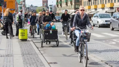
What's Behind Copenhagen's Success as a Cycling City?
Denmark's capital is a model city in terms of biking, but the reasons that bikes rule go beyond political leadership and robust infrastructure.
Where Will We All Park? A Slightly Premature Case Study of Hoboken, New Jersey
Hoboken, New Jersey's Department of Transportation and Parking Director Ian Sacs offers this profile of his city and discusses how the dense but car-enamored city is trying to tackle the contemporary urban parking problem.
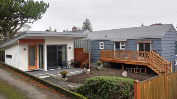
ADUs for Sale? San Diego Could Legalize Backyard Condos
As one of 25 proposed amendments, San Diego may soon allow accessory dwelling units to be bought and sold as individual homes.

Montreal Mall to Become 6,000 Housing Units
Place Versailles will be transformed into a mixed-use complex over the next 25 years.

Planetizen Federal Action Tracker
A weekly monitor of how Trump’s orders and actions are impacting planners and planning in America.

DARTSpace Platform Streamlines Dallas TOD Application Process
The Dallas transit agency hopes a shorter permitting timeline will boost transit-oriented development around rail stations.

Without International Immigrants, the Rural US Population Would Be Falling 58%
Census data shows that population growth in rural areas is due in large part to international migrants.

Dead End: Nine Highways Ready for Retirement
The Freeways Without Futures report describes the nation’s most promising highway removal proposals.

Congressman Proposes Bill to Rename DC Metro “Trump Train”
The Make Autorail Great Again Act would withhold federal funding to the system until the Washington Metropolitan Area Transit Authority (WMATA), rebrands as the Washington Metropolitan Authority for Greater Access (WMAGA).
Urban Design for Planners 1: Software Tools
This six-course series explores essential urban design concepts using open source software and equips planners with the tools they need to participate fully in the urban design process.
Planning for Universal Design
Learn the tools for implementing Universal Design in planning regulations.
City of Mt Shasta
City of Camden Redevelopment Agency
City of Astoria
Transportation Research & Education Center (TREC) at Portland State University
City of Camden Redevelopment Agency
Municipality of Princeton (NJ)
Regional Transportation Commission of Southern Nevada