


A few weeks ago, Randall O’Toole (a leading anti-anti-sprawl commentator) and Matthew Yglesias (a Washington-based pundit who primarily writes about politics, but occasionally veers off into planning issues) had an interesting discussion about the extent to which sprawl is a result of land use regulation.(1)

A few weeks ago, Randall O'Toole (a leading anti-anti-sprawl commentator) and Matthew
Yglesias (a Washington-based pundit who primarily writes about politics, but occasionally veers off into planning issues) had an
interesting discussion about the extent to which sprawl is a result of
land use
regulation.(1)
O'Toole argued that zoning does not play a major
role in
creating sprawl because historically, zoning "was used almost
exclusively in
areas that were already developed. Those original zones merely
reaffirmed the
development that was already there. Single-family neighborhoods were
zoned for
single-family homes; apartments for multi-family; industrial for
industry; and
so forth." By contrast, zoning in undeveloped
areas is more flexible; O'Toole writes that if a developer asks a city
or
county to rezone for more dense development, the government usually
complies.
In other words: if you want to
build in
the middle of nowhere, you can build what you like- even if you want to build something other than conventional sprawl.
But O'Toole's point is
perfectly consistent
with the possibility that if you want to build anywhere near any
existing
neighborhood, you risk running into a brick wall of zoning regulation designed to limit density and cater to "not in my backyard" (NIMBY) hostility to new development.
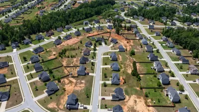
This difference between developed and undeveloped areas restricts compact development more than it restricts sprawl. Here's why: if you want to build a walkable
neighborhood,
you're probably going to want to build in a desirable intown or
inner-suburban
neighborhood, close to public transit.
After all, people who value walking to the nearest store are probably
more
likely to value proximity to transit than people who are just as happy
to drive
everywhere. So the dominant zoning system means that a landowner can build compact development- but not always where such development is most desirable, i.e. in areas near public transit (which tend to be older, established, heavily-zoned neighborhoods).
The restrictiveness of zoning laws
in developed
areas affects the location of development as well as its form: it increases the likelihood that
developers will prefer to build in the least developed
areas in order to avoid NIMBY objections and zoning restrictions that cater to NIMBYism.
O'Toole cites the Maricopa County, Arizona zoning code
as an example of developer-friendly zoning. The Maricopa code contains a provision for Planned Area of Development (PAD) districts,(2) which can be more compact than other
neighborhoods. But a developer still has to apply to get a parcel
rezoned to
PAD (3). Where do you think a PAD
application is more likely to be approved- in an inner suburb cheek by jowl with existing neighborhoods, or at the edge of
the
county dozens of miles away? Common sense suggests the latter.
My suspicion is not just a hunch.
In 2001, the Urban Land Institute surveyed
developers, asking them whether they would build more compactly
if
government regulation was less restrictive.
About 80% of developers responded that they would build more
compactly
in inner suburbs if government regulation was more permissive, as
opposed to less than 40% in rural areas.(4) In
other words, developers themselves believe that government regulation limits development in cities and inner suburbs.
In sum, even jurisdictions that are quite permissive towards "greenfield" development may be less permissive towards infill. This bias enourages developers to build in semirural suburbs, and is especially likely to reduce compact development.
(1) O'Toole's points are made at http://www.cato-at-liberty.org/2010/03/18/a-libertarian-view-of-urban-sprawl/
and
http://ti.org/antiplanner/?p=2887
; For Yglesias' post go to
http://yglesias.thinkprogress.org/archives/2010/03/centrally-planned-suburbia.php
(2) http://www.maricopa.gov/Planning/Resources/Ordinances/pdf/reform_ordinance/mczo1.pdf
, Ch. 10.
(3) Id.,
art. 1001.4
(4) Jonathan Levine, Zoned Out 131(2006). Cities and outer suburbs ranked between those extremes.


Commentary: We Need a Return to the Adaptability of Traditional Urban Form
How the rigidity of modern suburban development fails to prepare cities for the future.

To Build More Housing, Cities Must Be Smarter in How They Use Land
How strategic land use policy decisions can alleviate the housing crisis and limit unsustainable sprawl.
Commentary: Minimum Lot Sizes Drive Up Housing Costs
How making residential building requirements more flexible can ease the housing crisis and make neighborhoods more livable for more households.

Planetizen Federal Action Tracker
A weekly monitor of how Trump’s orders and actions are impacting planners and planning in America.

Restaurant Patios Were a Pandemic Win — Why Were They so Hard to Keep?
Social distancing requirements and changes in travel patterns prompted cities to pilot new uses for street and sidewalk space. Then it got complicated.

Map: Where Senate Republicans Want to Sell Your Public Lands
For public land advocates, the Senate Republicans’ proposal to sell millions of acres of public land in the West is “the biggest fight of their careers.”

Maui's Vacation Rental Debate Turns Ugly
Verbal attacks, misinformation campaigns and fistfights plague a high-stakes debate to convert thousands of vacation rentals into long-term housing.

San Francisco Suspends Traffic Calming Amidst Record Deaths
Citing “a challenging fiscal landscape,” the city will cease the program on the heels of 42 traffic deaths, including 24 pedestrians.

California Homeless Arrests, Citations Spike After Ruling
An investigation reveals that anti-homeless actions increased up to 500% after Grants Pass v. Johnson — even in cities claiming no policy change.
Urban Design for Planners 1: Software Tools
This six-course series explores essential urban design concepts using open source software and equips planners with the tools they need to participate fully in the urban design process.
Planning for Universal Design
Learn the tools for implementing Universal Design in planning regulations.
Heyer Gruel & Associates PA
JM Goldson LLC
Custer County Colorado
City of Camden Redevelopment Agency
City of Astoria
Transportation Research & Education Center (TREC) at Portland State University
Camden Redevelopment Agency
City of Claremont
Municipality of Princeton (NJ)