


Cities around the world are finding that turning industrial ruins into green public space is far more cost effective and fun than tearing them down.
"The High Line serves as a prime example of a new kind of park taking shape in countries such as the United States, Germany, Mexico, and Canada - one that uses the abandoned infrastructure and artifacts of industry to create distinctive public green spaces. Where we once understood parks to be the manicured places of respite envisioned by legendary landscape architects like Frederick Law Olmsted, creator of Manhattan's Central Park, they increasingly reflect recent urban history, seeking to create a positive legacy for what were once polluting structures.
One of the reasons for this change is economic: it's typically less expensive to reinvent industrial ruins than to remove them. Another is that cities are simply running out of green space. 'With Central Park, the land was acquired when Manhattan's growth was still very much on the tip of the island; same pattern with Golden Gate Park in San Francisco,' says Julia Czerniak, director of the Upstate design centre at the Syracuse University School of Architecture, and co-editor of the book Large Parks. 'Now we're going back into cities and finding military bases or old factories, and cobbling together vacant land, typically brownfields,' she notes, referring to contaminated sites. It's not that landscape architects enjoy cleaning up degraded sites, says Czerniak - 'That's just what we get.'"
FULL STORY: Green Giants

DC Park Aims for Equitable Development
Project leaders working on the 11th Street Bridge Park hope to prevent displacement of residents and bring economic and social benefits to the surrounding community.
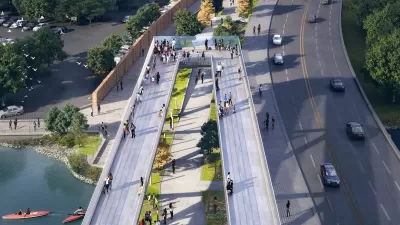
Meet Some of New York City's Newest Parks
In a city where density is everything, these park projects make creative use of existing public spaces—and, in some cases, create their own.
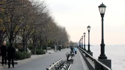
Brookyln Bridge Park Expands
The new park takes an old waterfront park and connects it with previously inaccessible space to create an 85-acre site stretching 1.3 miles along the waterfront.

Planetizen Federal Action Tracker
A weekly monitor of how Trump’s orders and actions are impacting planners and planning in America.

Map: Where Senate Republicans Want to Sell Your Public Lands
For public land advocates, the Senate Republicans’ proposal to sell millions of acres of public land in the West is “the biggest fight of their careers.”

Restaurant Patios Were a Pandemic Win — Why Were They so Hard to Keep?
Social distancing requirements and changes in travel patterns prompted cities to pilot new uses for street and sidewalk space. Then it got complicated.

Platform Pilsner: Vancouver Transit Agency Releases... a Beer?
TransLink will receive a portion of every sale of the four-pack.

Toronto Weighs Cheaper Transit, Parking Hikes for Major Events
Special event rates would take effect during large festivals, sports games and concerts to ‘discourage driving, manage congestion and free up space for transit.”

Berlin to Consider Car-Free Zone Larger Than Manhattan
The area bound by the 22-mile Ringbahn would still allow 12 uses of a private automobile per year per person, and several other exemptions.
Urban Design for Planners 1: Software Tools
This six-course series explores essential urban design concepts using open source software and equips planners with the tools they need to participate fully in the urban design process.
Planning for Universal Design
Learn the tools for implementing Universal Design in planning regulations.
Heyer Gruel & Associates PA
JM Goldson LLC
Custer County Colorado
City of Camden Redevelopment Agency
City of Astoria
Transportation Research & Education Center (TREC) at Portland State University
Camden Redevelopment Agency
City of Claremont
Municipality of Princeton (NJ)