


The new park takes an old waterfront park and connects it with previously inaccessible space to create an 85-acre site stretching 1.3 miles along the waterfront.
Chris Kannen of the Design Trust for Public Space got a tour of the new park space.
Kannen writes, "Pier 1 will open to the public this winter. It features open lawns with wide waterfront views not unlike Gantry Plaza State Park in Long Island City. The angle of the Brooklyn waterfront at this point affords long views of both New York Harbor and the East River, which are enhanced by the addition of gentle hills.
As you walk toward the water, the path approaches a stone platform that drops away like an infinity pool against the view of the water and Lower Manhattan. Steep steps connect to a promenade along the water's edge, which felt wider than the BQE. It was easy to imagine people hanging out on the steps like the 16th Street viewing platform on the High Line."
FULL STORY: Behind-the-Fence Tour of Brooklyn Bridge Park

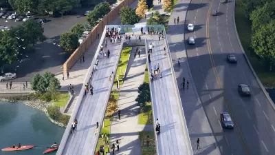
DC Park Aims for Equitable Development
Project leaders working on the 11th Street Bridge Park hope to prevent displacement of residents and bring economic and social benefits to the surrounding community.

Meet Some of New York City's Newest Parks
In a city where density is everything, these park projects make creative use of existing public spaces—and, in some cases, create their own.
Behind the Design of the Brooklyn Bridge Park
The new Brooklyn Bridge Park in New York is opening bit by bit. Places talks with Matthew Urbanski, one of the principal designers behind the park about its design and impact.

Planetizen Federal Action Tracker
A weekly monitor of how Trump’s orders and actions are impacting planners and planning in America.

Maui's Vacation Rental Debate Turns Ugly
Verbal attacks, misinformation campaigns and fistfights plague a high-stakes debate to convert thousands of vacation rentals into long-term housing.

San Francisco Suspends Traffic Calming Amidst Record Deaths
Citing “a challenging fiscal landscape,” the city will cease the program on the heels of 42 traffic deaths, including 24 pedestrians.

Defunct Pittsburgh Power Plant to Become Residential Tower
A decommissioned steam heat plant will be redeveloped into almost 100 affordable housing units.

Trump Prompts Restructuring of Transportation Research Board in “Unprecedented Overreach”
The TRB has eliminated more than half of its committees including those focused on climate, equity, and cities.

Amtrak Rolls Out New Orleans to Alabama “Mardi Gras” Train
The new service will operate morning and evening departures between Mobile and New Orleans.
Urban Design for Planners 1: Software Tools
This six-course series explores essential urban design concepts using open source software and equips planners with the tools they need to participate fully in the urban design process.
Planning for Universal Design
Learn the tools for implementing Universal Design in planning regulations.
Heyer Gruel & Associates PA
JM Goldson LLC
Custer County Colorado
City of Camden Redevelopment Agency
City of Astoria
Transportation Research & Education Center (TREC) at Portland State University
Jefferson Parish Government
Camden Redevelopment Agency
City of Claremont