


Guy Julier, designer and professor, talks about a number of design issues related to cities, including a detailed look at the pitfalls of waterfront development.
Julier was interviewed by Alex Gilks in New Zealand.
"The thing is, waterfront developments create problems in all kinds of ways, and they may look fine in themselves, but they run the danger of draining capital and resources (both private and public resources) from the rest of wherever the place is. That has happened to some degree in many places such as Cardiff. The second thing is that they basically replicate models of all other waterfront developments around the world, and waterfront developments have been around for a good 20-25 years now. They started off in America in the 1980s, particularly in Boston. You've got this gatey community effect as well, because often a waterfront development is looking away from a city and looking out to sea. And you've got then this problem of connectivity between the main part of a city and this waterfront development and so on. It's a very delicate thing."
FULL STORY: Interview: Guy Julier

Philly Waterfront Park Breaks Ground
Penn’s Landing is an ambitious redesign of 11.5 waterfront acres.
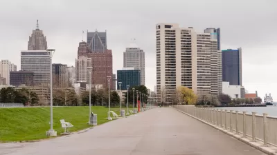
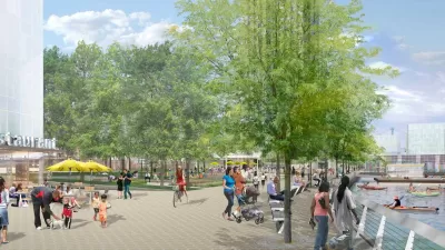
Shaping a 15-Minute City Vision for Detroit and Cleveland Using Data-Assisted Modeling
How master plans in the two cities hope to transform their historic, and historically underutilized, waterfronts.

Mayoral Op-Ed Touts New Equitable Development Model in Minneapolis
A plan for 48 acres of riverfront land could make Minneapolis a leader in doing redevelopment right, argue city leaders.

Planetizen Federal Action Tracker
A weekly monitor of how Trump’s orders and actions are impacting planners and planning in America.

Map: Where Senate Republicans Want to Sell Your Public Lands
For public land advocates, the Senate Republicans’ proposal to sell millions of acres of public land in the West is “the biggest fight of their careers.”

Restaurant Patios Were a Pandemic Win — Why Were They so Hard to Keep?
Social distancing requirements and changes in travel patterns prompted cities to pilot new uses for street and sidewalk space. Then it got complicated.

Platform Pilsner: Vancouver Transit Agency Releases... a Beer?
TransLink will receive a portion of every sale of the four-pack.

Toronto Weighs Cheaper Transit, Parking Hikes for Major Events
Special event rates would take effect during large festivals, sports games and concerts to ‘discourage driving, manage congestion and free up space for transit.”

Berlin to Consider Car-Free Zone Larger Than Manhattan
The area bound by the 22-mile Ringbahn would still allow 12 uses of a private automobile per year per person, and several other exemptions.
Urban Design for Planners 1: Software Tools
This six-course series explores essential urban design concepts using open source software and equips planners with the tools they need to participate fully in the urban design process.
Planning for Universal Design
Learn the tools for implementing Universal Design in planning regulations.
Heyer Gruel & Associates PA
JM Goldson LLC
Custer County Colorado
City of Camden Redevelopment Agency
City of Astoria
Transportation Research & Education Center (TREC) at Portland State University
Camden Redevelopment Agency
City of Claremont
Municipality of Princeton (NJ)