


Plans to redevelop a section of the Mississippi Riverfront in New Orleans have been approved and construction could begin by the end of 2009.
"The City Council recently approved the expenditure of $30 million in Community Development Block Grant funds for the public park, clearing the way for construction of the landmark project to begin before the end of the year."
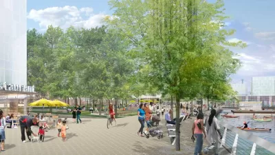
"The first phase will transform the area between Esplanade Avenue and Mazant Street. Now a gritty industrial zone marred by burned-out cargo docks, the area is set to become verdant green space replete with bike paths, pavilions, two piers and even electricity-generating windmills. If everything goes according to plan, the park will open in 2011."
"The designs reveal transformations of several decrepit wharves that now block pedestrian access to the waterfront. The fire-ravaged Mandeville Street Wharf will be replaced by a covered pavilion that could be used for outdoor concerts or other events. A wharf at Gallier Street would be rebuilt as a pier, allowing pedestrians to walk on a deck over the river. A second pier is planned at the foot of Press Street. A pavilion planned for Piety Street will have a musical theme, with plaques embedded in the ground to give facts about famous New Orleans musicians."
"In a city that has been slow to build affordable housing and other infrastructure since the 2005 storm, some have questioned whether a riverfront promenade is a necessary endeavor. Dubbed Reinventing the Crescent, the development would have additional phases that would extend the riverfront park from the Industrial Canal to Jackson Avenue. The entire project is slated to be complete in 2018."
FULL STORY: Architects present concept for redeveloping New Orleans riverfront

At Long Last, A Park on the Passaic?
A park proposed for Newark's Passaic River waterfront has been an unfulfilled vision for at least a decade. But city officials say the Trust for Public Land will help radically speed up plans for a park.
Philly Waterfront Park Breaks Ground
Penn’s Landing is an ambitious redesign of 11.5 waterfront acres.

Louisiana Coast Will Disappear, Study Says. The Only Question Is How Soon.
Sea-level rise has passed a tipping point in the Gulf of Mexico.

Planetizen Federal Action Tracker
A weekly monitor of how Trump’s orders and actions are impacting planners and planning in America.

Map: Where Senate Republicans Want to Sell Your Public Lands
For public land advocates, the Senate Republicans’ proposal to sell millions of acres of public land in the West is “the biggest fight of their careers.”

Restaurant Patios Were a Pandemic Win — Why Were They so Hard to Keep?
Social distancing requirements and changes in travel patterns prompted cities to pilot new uses for street and sidewalk space. Then it got complicated.

Platform Pilsner: Vancouver Transit Agency Releases... a Beer?
TransLink will receive a portion of every sale of the four-pack.

Toronto Weighs Cheaper Transit, Parking Hikes for Major Events
Special event rates would take effect during large festivals, sports games and concerts to ‘discourage driving, manage congestion and free up space for transit.”

Berlin to Consider Car-Free Zone Larger Than Manhattan
The area bound by the 22-mile Ringbahn would still allow 12 uses of a private automobile per year per person, and several other exemptions.
Urban Design for Planners 1: Software Tools
This six-course series explores essential urban design concepts using open source software and equips planners with the tools they need to participate fully in the urban design process.
Planning for Universal Design
Learn the tools for implementing Universal Design in planning regulations.
Heyer Gruel & Associates PA
JM Goldson LLC
Custer County Colorado
City of Camden Redevelopment Agency
City of Astoria
Transportation Research & Education Center (TREC) at Portland State University
Camden Redevelopment Agency
City of Claremont
Municipality of Princeton (NJ)