


Interactive maps of Manhattan from 1865 and 2008 are overlayed in this piece from The New York Moon that discusses the history of the island's waterways.
"Beneath New York's lattices of concrete, iron and landfill lie dozens of organic waterways. Using data from an 1865 sanitation map and contemporary satellite photographs, this projection depicts Manhattan as a vascular organ, whose obscure operation has had a powerful bearing on the fate of the city."
"Created for the department of sanitation, the map was a reminder that natural water systems, entombed beneath modern accumulations, hidden from view, could still have monumental effects on the functioning of city life. Indeed, structural engineers and city planners continue to consult the Viele map as the authoritative survey of Manhattan's water systems."
"In overlaying this map with a recent projection based on satellite photographs, this map seeks to continue to probe the relationship between the terrain we walk and the watery ateries below."
Thanks to BLDGBLOG
FULL STORY: Water Systems of Manhattan

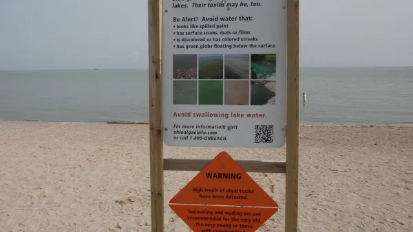
NOAA Great Lakes Lab Loses Key Funding
Cuts at a lab that monitors water quality in the Great Lakes region could harm efforts to prevent dangerous algal blooms.

USGS Water Science Centers Targeted for Closure
If their work is suspended, states could lose a valuable resource for monitoring, understanding, and managing water resources.
Restoring Northern India’s Himalayan ‘Water Temples’
Thousands of centuries-old buildings protect the region’s natural springs and serve as community wells and gathering places.

Planetizen Federal Action Tracker
A weekly monitor of how Trump’s orders and actions are impacting planners and planning in America.

Maui's Vacation Rental Debate Turns Ugly
Verbal attacks, misinformation campaigns and fistfights plague a high-stakes debate to convert thousands of vacation rentals into long-term housing.

San Francisco Suspends Traffic Calming Amidst Record Deaths
Citing “a challenging fiscal landscape,” the city will cease the program on the heels of 42 traffic deaths, including 24 pedestrians.

Defunct Pittsburgh Power Plant to Become Residential Tower
A decommissioned steam heat plant will be redeveloped into almost 100 affordable housing units.

Trump Prompts Restructuring of Transportation Research Board in “Unprecedented Overreach”
The TRB has eliminated more than half of its committees including those focused on climate, equity, and cities.

Amtrak Rolls Out New Orleans to Alabama “Mardi Gras” Train
The new service will operate morning and evening departures between Mobile and New Orleans.
Urban Design for Planners 1: Software Tools
This six-course series explores essential urban design concepts using open source software and equips planners with the tools they need to participate fully in the urban design process.
Planning for Universal Design
Learn the tools for implementing Universal Design in planning regulations.
Heyer Gruel & Associates PA
JM Goldson LLC
Custer County Colorado
City of Camden Redevelopment Agency
City of Astoria
Transportation Research & Education Center (TREC) at Portland State University
Jefferson Parish Government
Camden Redevelopment Agency
City of Claremont