


Integrated Environmental Solutions is releasing a free plug-in for Google's SketchUp software that allows users to run sustainability performance simulations.
"The same type of plug-in exists for AutoDesk Revit Architecture and MEP Building Information Modeling applications, but more designers and architects use Google SketchUp in the early stages of design, when sustainability is best addressed, according to Don McLean, IES' founder and managing director. The IES Toolbar plug-in to SketchUp makes sustainability analysis tools available to a wider range of professionals earlier in the design process, he says.
While designing in SketchUp, users assign sustainable design information such as location, building and room type, construction type, and HVAC systems, then engage with IES' software tools at varying levels to produce basic or complex analyses on multiple design iterations. The VE-Ware application provides basic energy and carbon performance analysis, using the Architecture 2030 Challenge as a benchmark for performance."
FULL STORY: building simulation plug-in available for google sketchup


Parks: Essential Community Infrastructure — and a Smart Investment
Even during times of budget constraint, continued investment in parks is critical, as they provide proven benefits to public health, safety, climate resilience, and community well-being — particularly for under-resourced communities.
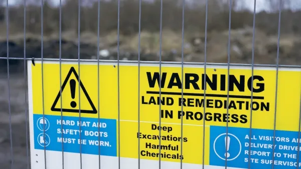
EPA Awards $267 Million to Clean Up and Reuse Contaminated Sites
The EPA is investing the funds to clean up and redevelop contaminated sites nationwide, supporting economic growth, community revitalization, and environmental restoration.

Honolulu Community College Celebrates Culture and Sustainability
Honolulu Community College brought together more than 320 students, staff, and community members for a day of Hawaiian cultural activities, music, and sustainability-focused learning at its annual Hoʻolauleʻa celebration.

Planetizen Federal Action Tracker
A weekly monitor of how Trump’s orders and actions are impacting planners and planning in America.

Map: Where Senate Republicans Want to Sell Your Public Lands
For public land advocates, the Senate Republicans’ proposal to sell millions of acres of public land in the West is “the biggest fight of their careers.”

Restaurant Patios Were a Pandemic Win — Why Were They so Hard to Keep?
Social distancing requirements and changes in travel patterns prompted cities to pilot new uses for street and sidewalk space. Then it got complicated.

Platform Pilsner: Vancouver Transit Agency Releases... a Beer?
TransLink will receive a portion of every sale of the four-pack.

Toronto Weighs Cheaper Transit, Parking Hikes for Major Events
Special event rates would take effect during large festivals, sports games and concerts to ‘discourage driving, manage congestion and free up space for transit.”

Berlin to Consider Car-Free Zone Larger Than Manhattan
The area bound by the 22-mile Ringbahn would still allow 12 uses of a private automobile per year per person, and several other exemptions.
Urban Design for Planners 1: Software Tools
This six-course series explores essential urban design concepts using open source software and equips planners with the tools they need to participate fully in the urban design process.
Planning for Universal Design
Learn the tools for implementing Universal Design in planning regulations.
Heyer Gruel & Associates PA
JM Goldson LLC
Custer County Colorado
City of Camden Redevelopment Agency
City of Astoria
Transportation Research & Education Center (TREC) at Portland State University
Camden Redevelopment Agency
City of Claremont
Municipality of Princeton (NJ)