


Anthony Townsend experiments with two powerful tools from Google that make it possible to visualize the view impacts of a new 26-story building in New York.
Using the two free tools offered by the Palo Alto-based Google, Townsend constructed a virtual model to see if a controversial new building in his neighborhood would block the view from his apartment. In a matter of 15 mintues, he designed a rough model that illustrated the proposed building's impacts.
"This could change the rules of urban planning forever, as people can instantly build models and visualize the impact of proposed development - something that used to take artists or expensive CAD systems," says Townsend. "Bye bye experts, the power is now in the people's hands."
Thanks to Anthony Townsend
FULL STORY: Fun With Google Earth and Sketchup


Planetizen Federal Action Tracker
A weekly monitor of how Trump’s orders and actions are impacting planners and planning in America.

Vehicle-related Deaths Drop 29% in Richmond, VA
The seventh year of the city's Vision Zero strategy also cut the number of people killed in alcohol-related crashes by half.
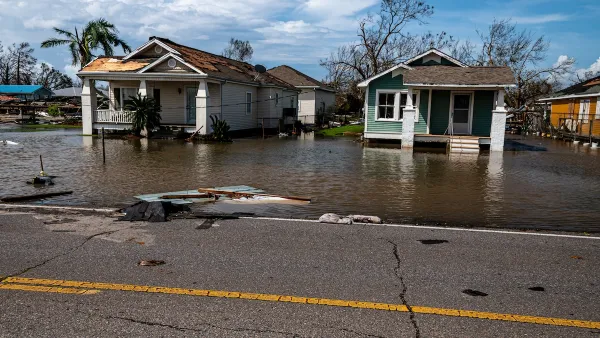
As Trump Phases Out FEMA, Is It Time to Flee the Floodplains?
With less federal funding available for disaster relief efforts, the need to relocate at-risk communities is more urgent than ever.

Texas Safety Advocates Raise Alarm in Advance of Tesla Robotaxi Launch
The company plans to deploy self-driving taxis in Austin with no oversight from state or local transportation agencies.

How to Fund SF’s Muni Without Cutting Service
Three solutions for bridging the San Francisco transit agency’s budget gap without reducing service for transit-dependent riders.

Austin Tests Self-Driving Bus
Autonomous buses could improve bus yard operations for electric fleets, according to CapMetro.
Urban Design for Planners 1: Software Tools
This six-course series explores essential urban design concepts using open source software and equips planners with the tools they need to participate fully in the urban design process.
Planning for Universal Design
Learn the tools for implementing Universal Design in planning regulations.
Borough of Carlisle
Smith Gee Studio
City of Camden Redevelopment Agency
City of Astoria
Transportation Research & Education Center (TREC) at Portland State University
City of Camden Redevelopment Agency
Municipality of Princeton (NJ)