


MIT researchers have developed a groundbreaking AI-powered tool that integrates physics-based models to generate realistic satellite images of future flooding, offering communities a powerful way to visualize and prepare for disasters.

Massachusetts Institute of Technology (MIT) scientists have developed an innovative method that combines generative artificial intelligence (AI) with a physics-based flood model to create realistic satellite images of future flooding events. This tool, called the "Earth Intelligence Engine," generates detailed, birds-eye-view visuals of regions expected to flood based on the strength and trajectory of approaching storms. As a proof of concept, the team tested the method on Houston, simulating flooding scenarios similar to Hurricane Harvey in 2017. The AI-generated images that incorporated the physics-based flood model proved more accurate and reliable than those generated by AI alone, which often included errors like flooding in areas of high elevation.
The method uses a conditional generative adversarial network (GAN) to produce realistic images by training two neural networks: one generates synthetic satellite images, and the other evaluates their accuracy against real images. While traditional GAN models risk "hallucinations," or inaccuracies in their results, the integration of physics-based parameters significantly reduces these errors. This enhanced approach provides a trustworthy visualization tool that could help policymakers and residents better understand potential flooding risks, making it more emotionally engaging and actionable than standard color-coded flood maps.
The research highlights the importance of pairing AI with trustworthy data sources, particularly in risk-sensitive scenarios like natural disasters. By visualizing potential flooding before a hurricane hits, this technology has the potential to enhance public preparedness and decision-making, such as evacuation planning. While further training on diverse satellite images is needed to apply the model to other regions, the method demonstrates how AI, combined with physics, can support community-level decision-making and potentially save lives.
FULL STORY: New AI tool generates realistic satellite images of future flooding


Rising Above: Innovative Solutions for Waikīkī’s Sea-Level Challenges
The University of Hawaiʻi at Mānoa’s award-winning Waikīkī sea-level rise adaptation project combines science, architecture, and community input to create scalable solutions for climate resilience and coastal flood mitigation.
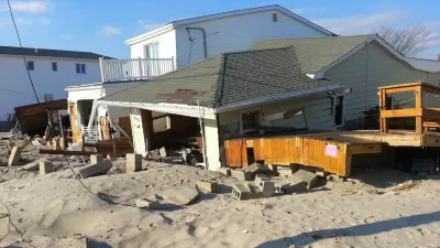
FEMA Rule Calls for Updated Flood Modeling
Agency-funded projects will be required to be elevated at least 2 feet above the projected local flood level.

3D Modeling Aids in Predicting Hurricane Damage
Texas researchers are testing the tool in Galveston, where Hurricane Ike caused billions in damage in 2008.

Planetizen Federal Action Tracker
A weekly monitor of how Trump’s orders and actions are impacting planners and planning in America.

Congressman Proposes Bill to Rename DC Metro “Trump Train”
The Make Autorail Great Again Act would withhold federal funding to the system until the Washington Metropolitan Area Transit Authority (WMATA), rebrands as the Washington Metropolitan Authority for Greater Access (WMAGA).

The Simple Legislative Tool Transforming Vacant Downtowns
In California, Michigan and Georgia, an easy win is bringing dollars — and delight — back to city centers.

The States Losing Rural Delivery Rooms at an Alarming Pace
In some states, as few as 9% of rural hospitals still deliver babies. As a result, rising pre-term births, no adequate pre-term care and harrowing close calls are a growing reality.

The Small South Asian Republic Going all in on EVs
Thanks to one simple policy change less than five years ago, 65% of new cars in this Himalayan country are now electric.

DC Backpedals on Bike Lane Protection, Swaps Barriers for Paint
Citing aesthetic concerns, the city is removing the concrete barriers and flexposts that once separated Arizona Avenue cyclists from motor vehicles.
Urban Design for Planners 1: Software Tools
This six-course series explores essential urban design concepts using open source software and equips planners with the tools they need to participate fully in the urban design process.
Planning for Universal Design
Learn the tools for implementing Universal Design in planning regulations.
Smith Gee Studio
City of Charlotte
City of Camden Redevelopment Agency
City of Astoria
Transportation Research & Education Center (TREC) at Portland State University
US High Speed Rail Association
City of Camden Redevelopment Agency
Municipality of Princeton (NJ)