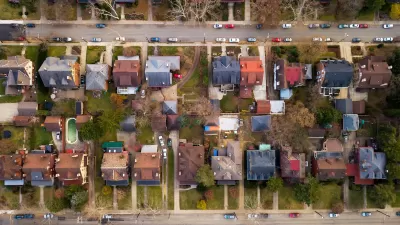
The proposed changes would permit more flexible housing development while limiting changes in historic neighborhoods and on smaller streets.

A zoning reform proposal from Milwaukee Mayor Cavalier Johnson aims to promote a wider variety of housing types and make housing more affordable, writes Jeramey Jannere in Urban Milwaukee. The proposal calls for allowing live-work units and accessory dwelling units (ADUs) in most of the city, allowing three- and four-story buildings in more zones, and unbundling the cost of parking from rent, among other adjustments. Today, 40 percent of residential zones in Milwaukee allow only single-family homes.
The changes would largely affect commercial corridors and areas near transit. “At the same time it allows more options across the city, it also has components, based on lot width and other factors, designed to restrict large or wide new buildings from being developed in historic lower-density residential areas. The net result is an attempt to drive the highest density new development to commercial areas or existing high-density areas, while allowing only incremental changes in density on residential side streets.” Critics of this practice warn that limiting upzoning to major streets disproportionately exposes residents of multifamily housing to air pollution and other impacts.
FULL STORY: Zoning Changes Would Clear Path To 1 Million Residents (Milwaukee)

Montreal Mall to Become 6,000 Housing Units
Place Versailles will be transformed into a mixed-use complex over the next 25 years.

Planetizen Federal Action Tracker
A weekly monitor of how Trump’s orders and actions are impacting planners and planning in America.

DARTSpace Platform Streamlines Dallas TOD Application Process
The Dallas transit agency hopes a shorter permitting timeline will boost transit-oriented development around rail stations.

Interactive Map Reveals America's “Shade Deserts”
Launched by UCLA and American Forests to combat heat-related deaths, the tool maps the shade infrastructure for over 360 U.S. cities.

Bicycles and Books — In Sacramento, Libraries Now Offer Both
Adult library card holders can check out e-bikes and e-trikes for up to one week.

Colorado Landfills Emit as Much Pollution as 1M Cars
Landfills are the third-largest source of methane pollution in Colorado, after agriculture and fossil fuel extraction.
Urban Design for Planners 1: Software Tools
This six-course series explores essential urban design concepts using open source software and equips planners with the tools they need to participate fully in the urban design process.
Planning for Universal Design
Learn the tools for implementing Universal Design in planning regulations.
City of Mt Shasta
City of Camden Redevelopment Agency
City of Astoria
Transportation Research & Education Center (TREC) at Portland State University
US High Speed Rail Association
City of Camden Redevelopment Agency
Municipality of Princeton (NJ)


