


A segment of California’s famous Highway 1 collapsed, leaving the area completely cut off for a day and the southbound lane of the road still closed.
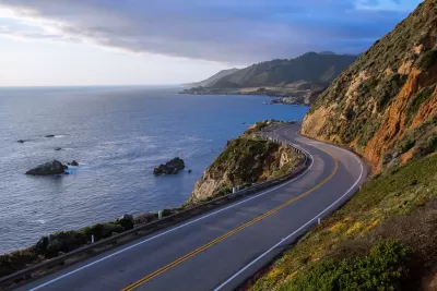
Roughly 1,600 people were stranded on California’s Big Sur coast when a segment of Highway 1, a road originally built in the 1930s that hugs the scenic coast, collapsed, cutting off the hamlet from the rest of the state.
According to a Los Angeles Times article by Jireh Deng and Thomas Curwen, “Officials discovered a slip-out on the southbound lane early Saturday evening and quickly closed the road to further vehicle travel to assess damage.”
Residents of the isolated coastal community are used to occasional landslides. “But the afternoon closure of Highway 1 at Rocky Creek Bridge — on a critical stretch connecting Big Sur with Carmel-By-the-Sea — caught visitors and businesses by surprise.”
Caltrans began escorting cars on the northbound lane on Sunday. “This weekend, officials are planning to install a 500-foot concrete barrier down the center line of the road to make an isolated channel for motorists, according to Kevin Drabinski, spokesperson for Caltrans District 5.”
Some residents believe the area needs another access point as coastal erosion and landslides become more common.
FULL STORY: Big Sur tourism 'on standstill' after its connecting roadway crumbles into the sea -- again

Workers Returning, Carefully, to the Scene of Epic Landslide on the California Coast
Engineers are searching for solid ground along the California coast at the scene of a massive landslide that wiped out California Highway 1 near San Luis Obispo.
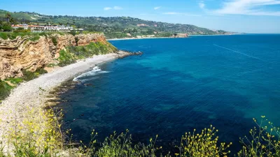
Southern California City Offers Buyout to Homeowners Facing Erosion Threat
Power and gas were shut off to dozens of homes in Rancho Palos Verdes as landslides threatened homes and infrastructure. Now, the city is offering to buy the homes to help residents relocate.

Southern California Utilities Cut Power, Gas to Hundreds of Households on Shifting Coastal Land
Slow but significant land movement is damaging infrastructure, prompting power shutoffs and calls for evacuation in Rancho Palos Verdes.

Planetizen Federal Action Tracker
A weekly monitor of how Trump’s orders and actions are impacting planners and planning in America.

San Francisco's School District Spent $105M To Build Affordable Housing for Teachers — And That's Just the Beginning
SFUSD joins a growing list of school districts using their land holdings to address housing affordability challenges faced by their own employees.

The Tiny, Adorable $7,000 Car Turning Japan Onto EVs
The single seat Mibot charges from a regular plug as quickly as an iPad, and is about half the price of an average EV.

Seattle's Plan for Adopting Driverless Cars
Equity, safety, accessibility and affordability are front of mind as the city prepares for robotaxis and other autonomous vehicles.

As Trump Phases Out FEMA, Is It Time to Flee the Floodplains?
With less federal funding available for disaster relief efforts, the need to relocate at-risk communities is more urgent than ever.

With Protected Lanes, 460% More People Commute by Bike
For those needing more ammo, more data proving what we already knew is here.
Urban Design for Planners 1: Software Tools
This six-course series explores essential urban design concepts using open source software and equips planners with the tools they need to participate fully in the urban design process.
Planning for Universal Design
Learn the tools for implementing Universal Design in planning regulations.
Smith Gee Studio
City of Charlotte
City of Camden Redevelopment Agency
City of Astoria
Transportation Research & Education Center (TREC) at Portland State University
US High Speed Rail Association
City of Camden Redevelopment Agency
Municipality of Princeton (NJ)