


A series of hasty removals of land from the protected Greenbelt last year were pushed through without environmental or financial analysis.

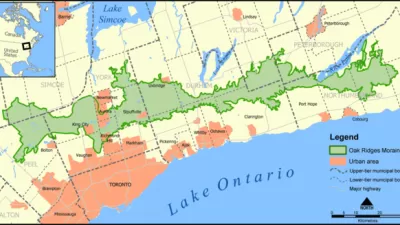
A report from Ontario’s Auditor-General reveals that the provincial government removed 3,000 hectares (7,400 acres) from Toronto’s protected Greenbelt to favor certain developers and without appropriate environmental or financial analysis.
As Jeff Gray explains in The Globe and Mail, “The report by Auditor-General Bonnie Lysyk also estimates, based on 2016 data from the Municipal Property Assessment Corp. (MPAC), that the landowners of the 15 formerly protected sites opened up for housing last year could see their worth balloon by more than $8.3-billion.”
The Greenbelt is a 800,000-hectare area surrounding the city created in 2005 to limit sprawl and protect local farmland. Last year, Premier Doug Ford’s government redrew its boundaries in an effort, according to Ford, to create 50,000 new units of much-needed housing.
According to the report, “All but one of the properties removed from the Greenbelt, in what the Auditor-General calls a ‘seriously flawed’ process that took just three weeks, were identified for a small group of civil servants assigned to work on the project by Ryan Amato, the chief of staff to Mr. Clark.” The article continues, “The extremely tight timeline and confidentiality provisions, the audit says, meant bureaucrats could not fully analyze the environmental impact or provide alternatives to the Greenbelt removals.”
FULL STORY: Ford’s Greenbelt removals ‘favoured’ certain developers, Ontario’s Auditor-General says


In Reversal, Ontario Government Could Open Toronto Greenbelt to Development
The Toronto Greenbelt was an urban growth boundary created in 2005 as one of the most obvious political victories for the Smart Growth movement in North America. A new bill would reverse course on the region’s growth policies.
Doug Ford, Candidate for Ontario Premier, Would Open Toronto Greenbelt to Development
A prominent conservative with an infamous name is promoting single-family home development in the Toronto greenbelt as a way to release pressure on the Toronto housing market.

Proposed Toronto Highways Raise Environmental Concerns
Opponents of two new planned highways in greater Toronto argue the construction of new roads is 'short-sighted at best' and would threaten the region's greenbelt areas.

Planetizen Federal Action Tracker
A weekly monitor of how Trump’s orders and actions are impacting planners and planning in America.

Congressman Proposes Bill to Rename DC Metro “Trump Train”
The Make Autorail Great Again Act would withhold federal funding to the system until the Washington Metropolitan Area Transit Authority (WMATA), rebrands as the Washington Metropolitan Authority for Greater Access (WMAGA).

DARTSpace Platform Streamlines Dallas TOD Application Process
The Dallas transit agency hopes a shorter permitting timeline will boost transit-oriented development around rail stations.

Renters Now Outnumber Homeowners in Over 200 US Suburbs
High housing costs in city centers and the new-found flexibility offered by remote work are pushing more renters to suburban areas.

The Tiny, Adorable $7,000 Car Turning Japan Onto EVs
The single seat Mibot charges from a regular plug as quickly as an iPad, and is about half the price of an average EV.

Supreme Court Ruling in Pipeline Case Guts Federal Environmental Law
The decision limits the scope of a federal law that mandates extensive environmental impact reviews of energy, infrastructure, and transportation projects.
Urban Design for Planners 1: Software Tools
This six-course series explores essential urban design concepts using open source software and equips planners with the tools they need to participate fully in the urban design process.
Planning for Universal Design
Learn the tools for implementing Universal Design in planning regulations.
Municipality of Princeton
Roanoke Valley-Alleghany Regional Commission
City of Mt Shasta
City of Camden Redevelopment Agency
City of Astoria
Transportation Research & Education Center (TREC) at Portland State University
US High Speed Rail Association
City of Camden Redevelopment Agency
Municipality of Princeton (NJ)