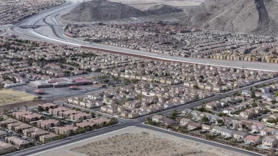
The southeast Texas city is responding to community demands for safer, more accessible, and more diverse transportation choices.

Sugar Land, Texas,is adopting a new Mobility Master Plan aimed at aligning the goals and proposals in prior mobility, roadway, and bike and pedestrian plans and improving mobility for all types of road users in the sprawling, heavily car-oriented city southwest of Houston.
An article in the Fort Bend Independent quotes the master plan, which states:
For decades Sugar Land has successfully invested in mobility, primarily by building new streets and trails and increasing vehicular capacity.
To complement these investments, the community has asked the City to expand safe, healthy, and active transportation choices for all users, and continue to deploy mobility technology and update design treatments to optimize the space on existing streets.
The plan highlights the interconnectedness of transportation and land use policies, noting that “City staff should integrate public health considerations into all facets of transportation decision-making. This includes expanding greenspace for healthy activities, improving air quality, and ensuring that everyone can access their day-to-day destinations without a car.”
According to the plan, “the City must strategically re-imagine existing street corridors, build on innovative Intelligent Transportation System (ITS) investments, and adapt existing programs and policies to meet the evolving needs of the community.”
The plan establishes six ‘mobility metrics’ and a framework for tracking progress. “This plan identifies focus corridors for investment in a connected Transformative Mobility Network (TMN). Alongside this network, targeted Strategies & Action Items detail the projects, programs, and policies for the City to pursue over the next decade.”
The plan adds, “This Strategy supports further investment in the existing demand response and park & ride services within Fort Bend County while also exploring other options, including microtransit, that support connectivity and access for Sugar Land residents, businesses, and commuters.” As part of the city’s goal to provide more transportation options, in May, the city applied for a grant from the Houston-Galveston Area Council (H-GAC) to establish an on-demand microtransit pilot program.
FULL STORY: Sugar Land Reimagines The City’s Future With A New Mobility Master Plan

Rethinking Redlining
For decades we have blamed 100-year-old maps for the patterns of spatial racial inequity that persist in American cities today. An esteemed researcher says: we’ve got it all wrong.

Montreal Mall to Become 6,000 Housing Units
Place Versailles will be transformed into a mixed-use complex over the next 25 years.

Planetizen Federal Action Tracker
A weekly monitor of how Trump’s orders and actions are impacting planners and planning in America.

Connecting Communities to Nature Close to Home
Los Angeles County’s Nature in Your Neighborhood program brings free, family-friendly wellness and nature activities to local parks, making it easier for residents to enjoy and connect with the outdoors.

Palmdale’s Beloved Water Park Gets $2 Million Upgrade
To mark its 20th anniversary, DryTown Water Park has undergone major renovations, ensuring that families across the Antelope Valley continue to enjoy safe, affordable, and much-needed water-based recreation in the high desert.

Help Stop the Beetle Killing Southern California’s Oak Trees
Claifornia residents can join a volunteer “blitz” this June to help detect and map infestations of an invasive beetle that is killing thousands of oak trees across Southern California.
Urban Design for Planners 1: Software Tools
This six-course series explores essential urban design concepts using open source software and equips planners with the tools they need to participate fully in the urban design process.
Planning for Universal Design
Learn the tools for implementing Universal Design in planning regulations.
Heyer Gruel & Associates PA
City of Clovis
City of Camden Redevelopment Agency
City of Astoria
Transportation Research & Education Center (TREC) at Portland State University
Regional Transportation Commission of Southern Nevada
Toledo-Lucas County Plan Commissions


