


Learn more about Los Angeles County's Parks Needs Assessment Plus (PNA+) which focuses on land conservation and restoration, regional recreation, and rural recreation to address climate change, protect biodiversity, and meet the needs of residents.

“30x30” refers to the goal of conserving 30 percent of lands and coastal waters by 2030 to address climate change and protect biodiversity. On December 6, 2022, the Los Angeles County Board of Supervisors unanimously adopted the 2022 Parks Needs Assessment Plus (PNA+) Final Report as its 30x30 plan, aligning the county with the U.S. government and the state of California which have also made commitments to achieve 30x30.
In this article, park planner Clement Lau discusses the PNA+ Final Report which addresses land conservation and restoration, regional recreation, and rural recreation. The PNA+ builds upon and supplements the 2016 Parks Needs Assessment (PNA) with data, mapping, and analyses to guide future environmental conservation and restoration efforts across the county as well as information about regional and rural recreation needs. Like the 2016 PNA, the PNA+ involved data collection and analysis, mapping using geographic information system (GIS), coordination with park and trail managing agencies, and public outreach and engagement in partnership with community-based organizations (CBOs).
The PNA+ focuses on the most vulnerable residents living in park-poor, tree-poor urban and rural areas with limited access to local and regional parks and recreational facilities. Vulnerable communities are identified and mapped using data from the Healthy Places Index (HPI), including indicators that address four dimensions: 1) social barriers like poverty and unemployment; 2) transportation barriers like limited access to public transit or automobile; 3) health vulnerability like reduced life expectancy at birth; and 4) environmental vulnerability like a high number of excessive heat days and limited tree canopy.
The PNA+ identifies priority areas for environmental conservation and restoration which form the basis for a 30x30 plan for L.A. County. This strategy reimagines conservation through an equity lens to include both traditional efforts that involve the protection of natural lands and the restoration of degraded lands, especially in lower-income communities of color where vulnerable populations and environmental burdens are concentrated.
FULL STORY: Time To Re-Focus

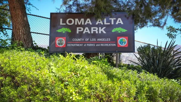
A Park Reborn: Resilience and Renewal in Fire-Stricken Altadena
Rebuilt in just two months after the devastating Eaton Fire, Loma Alta Park now stands as a symbol of community resilience and renewal, even as some residents hope recovery efforts will continue to support housing stability and long-term equity.

Expanding Green Spaces in Greater LA: Challenges and Solutions
Creating parks and open space in L.A. County requires overcoming land scarcity, high costs, and other challenges through strategic partnerships, innovative multi-benefit designs, and policy reforms to ensure equitable access and sustainability.
A Greener LA County: 623 Acres of New Parkland for Communities
Los Angeles County is investing $17 million to create 623 acres of new parks and open spaces, expanding access to nature, advancing equity, and enhancing community health and well-being.

Planetizen Federal Action Tracker
A weekly monitor of how Trump’s orders and actions are impacting planners and planning in America.

DARTSpace Platform Streamlines Dallas TOD Application Process
The Dallas transit agency hopes a shorter permitting timeline will boost transit-oriented development around rail stations.

Congressman Proposes Bill to Rename DC Metro “Trump Train”
The Make Autorail Great Again Act would withhold federal funding to the system until the Washington Metropolitan Area Transit Authority (WMATA), rebrands as the Washington Metropolitan Authority for Greater Access (WMAGA).

Supreme Court Ruling in Pipeline Case Guts Federal Environmental Law
The decision limits the scope of a federal law that mandates extensive environmental impact reviews of energy, infrastructure, and transportation projects.

Texas State Bills to Defund Dallas Transit Die
DART would have seen a 30% service cut, $230M annual losses had the bills survived.

Bikeshare for the Win: Team Pedals to London Cricket Match, Beats Rivals Stuck in Traffic
While their opponents sat in gridlock, England's national cricket team hopped Lime bikes, riding to a 3-0 victory.
Urban Design for Planners 1: Software Tools
This six-course series explores essential urban design concepts using open source software and equips planners with the tools they need to participate fully in the urban design process.
Planning for Universal Design
Learn the tools for implementing Universal Design in planning regulations.
Roanoke Valley-Alleghany Regional Commission
City of Mt Shasta
City of Camden Redevelopment Agency
City of Astoria
Transportation Research & Education Center (TREC) at Portland State University
US High Speed Rail Association
City of Camden Redevelopment Agency
Municipality of Princeton (NJ)