


An executive order signed last week consolidates actions the city plans to take to reduce greenhouse gas emissions.
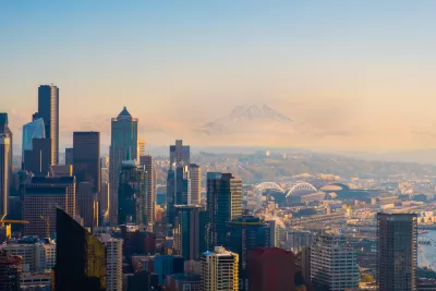
As part of an executive order signed last Wednesday, Seattle Mayor Bruce Harrell has directed the city to create three “low-pollution neighborhoods” in the next five years as part of the city’s commitment to reduce carbon emissions.
The executive order, according to The Urbanist’s Ryan Packer, includes “overly broad” language that “leaves the door open to multiple strategies, with several options on the table likely presenting bigger political battles than others.”
The options range from the superblock strategy, which limits the types of vehicles that can access certain areas and reduces traffic on smaller streets, to further investment in bus-only lanes and a commitment to create safe and accessible bike facilities near every school. “In an interview following Harrell’s announcement, Jessyn Farrell said that the city would be focusing on strategies that have been proven to work for shifting commute trips — transit, parking pricing — to non-commute trips, with an intentional focus on school-related trips.”
Packer criticizes the executive order for its vagueness, writing that “Long-range plans and vague commitments have abounded, but a clear vision and action in the here and now has been lacking.” According to Packer, the city has not made significant progress toward meeting its 2013 Climate Action Plan goals.
FULL STORY: Harrell Pledges Three “Low-Pollution Neighborhoods” by 2028

Assessing Prince George's County's Climate Action Plan
The Prince George's County draft Climate Action Plan includes ambitious goals and timetables, but falls short of recommended targets for emissions reductions in the transportation sector.
Seattle's 'Electrification Blueprint' Sets Ambitious Goals
The city's new transportation plan focuses on eliminating carbon emissions in its transportation sector, reducing congestion, and boosting public transit.

Driving Equity and Clean Air: California Invests in Greener School Transportation
California has awarded $500 million to fund 1,000 zero-emission school buses and chargers for educational agencies as part of its effort to reduce pollution, improve student health, and accelerate the transition to clean transportation.

Planetizen Federal Action Tracker
A weekly monitor of how Trump’s orders and actions are impacting planners and planning in America.

Congressman Proposes Bill to Rename DC Metro “Trump Train”
The Make Autorail Great Again Act would withhold federal funding to the system until the Washington Metropolitan Area Transit Authority (WMATA), rebrands as the Washington Metropolitan Authority for Greater Access (WMAGA).

DARTSpace Platform Streamlines Dallas TOD Application Process
The Dallas transit agency hopes a shorter permitting timeline will boost transit-oriented development around rail stations.

San Francisco's School District Spent $105M To Build Affordable Housing for Teachers — And That's Just the Beginning
SFUSD joins a growing list of school districts using their land holdings to address housing affordability challenges faced by their own employees.

Car-Centric LA Suburb Looks to a Train-Oriented Future
City leaders in Rancho Cucamonga, the future western terminus of the Brightline West rail line to Las Vegas, want to reimagine the city as a transit-oriented, pedestrian-friendly community.

New Alaska Bitcoin Mine Would Burn as Much Energy as the State’s Largest Coal Plant
Fueled by “stranded” natural gas, the startup hopes to become the largest in the US, and to make Alaska an industry center.
Urban Design for Planners 1: Software Tools
This six-course series explores essential urban design concepts using open source software and equips planners with the tools they need to participate fully in the urban design process.
Planning for Universal Design
Learn the tools for implementing Universal Design in planning regulations.
Municipality of Princeton
Roanoke Valley-Alleghany Regional Commission
City of Mt Shasta
City of Camden Redevelopment Agency
City of Astoria
Transportation Research & Education Center (TREC) at Portland State University
US High Speed Rail Association
City of Camden Redevelopment Agency
Municipality of Princeton (NJ)