


The Florida city will make improvements on two downtown streets to make them safer and more pedestrian-friendly.

As reported by Sarasota Magazine, “The City of Sarasota will unveil draft concepts for the construction of ‘complete streets’ on 10th Street and Boulevard of the Arts at two upcoming open houses.”
According to the article, “The projects will modify various intersections throughout the corridors that encompass neighborhoods that have been traditionally underserved, as well as historical districts. This project also links communities to recreational trail paths, employment centers, parks, essential services, schools, public amenities, the Rosemary District, Central Cocoanut, Gillespie Park, Downtown, the Quay and the Bay Park. ”
The plan is based on public input gathered in a February survey. “The public’s vision was incorporated into the conceptual designs for the complete streets, which will be presented in two sessions on Monday, May 23, in the City Hall Annex.”
The Complete Streets model aims to prioritize the needs of pedestrians, cyclists, and people with mobility impairments by making streets safe and accessible and reducing the focus on traffic throughput.
FULL STORY: City of Sarasota to Unveil ‘Complete Street’ Designs Next Week


Sacramento Plans ‘Quick-Build’ Road Safety Projects
The city wants to accelerate small-scale safety improvements that use low-cost equipment to make an impact at dangerous intersections.
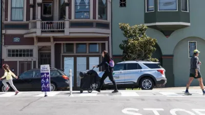
San Francisco Slow Streets Bucks Citywide Trend, Reducing Injuries by 61 Percent
Low-cost interventions aimed at slowing traffic are making a major impact on road safety.

‘Complete Streets’ Webpage Deleted in Federal Purge
Basic resources and information on building bike lanes and sidewalks, formerly housed on the government’s Complete Streets website, are now gone.

Montreal Mall to Become 6,000 Housing Units
Place Versailles will be transformed into a mixed-use complex over the next 25 years.

Planetizen Federal Action Tracker
A weekly monitor of how Trump’s orders and actions are impacting planners and planning in America.

Four Reasons Urban Planners Can’t Ignore AI
It’s no longer a question of whether AI will shape planning, but how. That how is up to us.

Bend, Deschutes County Move to Restrict Major Homeless Encampment
City and county officials are closing off portions of an area known as Juniper Ridge where many unhoused residents find shelter, hoping to direct people to housing and supportive services.

High Housing Costs Driving Down Transit Ridership in LA
When neighborhoods gentrify and displace lower-income residents, transit ridership suffers, new research shows.

Iowa Legalizes Accessory Dwelling Units
A new law will allow property owners to build ADUs on single-family lots starting on July 1.
Urban Design for Planners 1: Software Tools
This six-course series explores essential urban design concepts using open source software and equips planners with the tools they need to participate fully in the urban design process.
Planning for Universal Design
Learn the tools for implementing Universal Design in planning regulations.
City of Mt Shasta
City of Camden Redevelopment Agency
City of Astoria
Transportation Research & Education Center (TREC) at Portland State University
City of Camden Redevelopment Agency
Municipality of Princeton (NJ)
Regional Transportation Commission of Southern Nevada