


With 27 transit agencies, traveling across the Bay Area can be a daunting task. Advocates for 'seamless transit' want to change that.
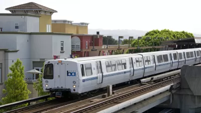
A blog post from TransitCenter explains the San Francisco Bay Area's complicated transit system, which boasts 27 different agencies across nine counties.
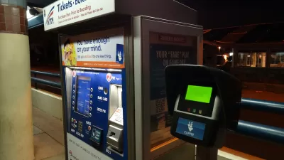
The introduction of the Clipper Card in 2002 was intended to help. For the first time, riders could use the same payment card for rides across the region. But the technology alone wasn’t enough to solve the problem. To this day, riders whose trips require them to use multiple agencies still face a penalty – interagency transfers are only sparingly accepted, and most agencies don’t coordinate their schedules, creating long waits between transfers.
Thanks in part to advocacy from a group calling itself Seamless Bay Area, a proposed state bill dubbed the "Seamless Transit Transformation Act" would mandate an integrated fare structure by 2024 and require transit agencies to coordinate schedules, service, and maps in order to receive state funding. "With the Bay Area’s infamous housing costs continuing to push people further from employment centers and ridership slow to recover from the pandemic, the initiative could be the key to bringing back riders, and making transit a viable option for tens of thousands more people," the blog states.
"There have been various attempts at fare integration over the last several decades, but the efforts haven’t been resourced or coordinated enough to be successful." To find out why, "According to [Seamless’s Advocacy Director, Adina Levin], Seamless looked at where previous integration efforts had fallen short, and brought in equity-focused groups and elected officials to the task force process and accompanying outreach in order to increase the likelihood of success." The organization has focused on developing a plan to integrate the dozens of agencies under one umbrella, with questions of logistics and revenue share still to be decided.
FULL STORY: Towards a Seamless Bay Area

Opinion: Fare Evasion Punished Disproportionately in California
A bill currently on Governor Newsom’s desk would replace punitive measures with more equitable and compassionate approaches to fare enforcement.

L.A. Metro Launches Fare Capping Program
Transit fares will be capped at $5 per day for all riders who pay with TAP cards, whether or not they have weekly or monthly passes.
Connecticut’s Ends Fare-Free Pilot
State officials say federal requirements forced the end of a twelve-month pilot program, and that the state doesn’t have the funding to continue providing free fares with the end of federal assistance.

Rethinking Redlining
For decades we have blamed 100-year-old maps for the patterns of spatial racial inequity that persist in American cities today. An esteemed researcher says: we’ve got it all wrong.

Planetizen Federal Action Tracker
A weekly monitor of how Trump’s orders and actions are impacting planners and planning in America.

California High-Speed Rail's Plan to Right Itself
The railroad's new CEO thinks he can get the project back on track. The stars will need to align this summer.

US Senate Reverses California EV Mandate
The state planned to phase out the sale of gas-powered cars by 2035, a goal some carmakers deemed impossible to meet.

Trump Cuts Decimate Mapping Agency
The National Geodetic Survey maintains and updates critical spatial reference systems used extensively in both the public and private sectors.

Washington Passes First US ‘Shared Streets’ Law
Cities will be allowed to lower speed limits to 10 miles per hour and prioritize pedestrians on certain streets.
Urban Design for Planners 1: Software Tools
This six-course series explores essential urban design concepts using open source software and equips planners with the tools they need to participate fully in the urban design process.
Planning for Universal Design
Learn the tools for implementing Universal Design in planning regulations.
City of Camden Redevelopment Agency
City of Astoria
Transportation Research & Education Center (TREC) at Portland State University
Regional Transportation Commission of Southern Nevada
Toledo-Lucas County Plan Commissions