


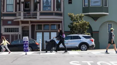
Decatur's Church Street is set to undergo a transformation that will reduce traffic lanes, add cycletracks, and widen sidewalks in an effort to make the corridor more 'people-friendly.'

A 'people-friendly' makeover is underway in Decatur, Georgia, where the Clairemont-Commerce-Church Street Pedestrian Safety and Bicycle Trail improvement program is transforming a mile of Church Street into a safer, more walkable and bikeable corridor with separated cycletracks and wider sidewalks that will replace two vehicle lanes. As Josh Green writes in Urbanize Atlanta, "The result should make Church Street feel less residential highway and more parkway, where traffic naturally slows down, project leaders say."
"Closer to downtown Decatur, the project will improve pedestrian crossings, eliminate 'slip lanes' for cars, and bring the cycle track around to connect with existing bike lanes on Commerce Drive," Green goes on to explain. The $4 million project is funded in large part through grants from Atlanta Regional Commission and the Georgia Department of Transportation and is expected to take over a year to complete. "But the payoff will be an attractive and safer pedestrian and bicycle-oriented urban street," according to the deputy city manager.
"In recent years, Decatur and its partners have installed protected bike lanes and cycle tracks on the eastern fringes of downtown along Commerce Drive and in front of Decatur High School." Green notes that Decatur recently became the smallest city to achieve the Walk Friendly Communities "Gold Level Walk Friendly Community" rating.
FULL STORY: In Decatur, people-friendly road transformation is full speed ahead


Maryland Plans Quick-Build Complete Streets Projects
The state will use low-cost interventions to improve road safety in five Maryland counties.
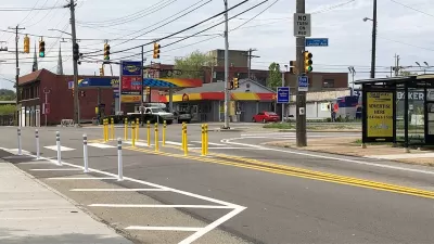
San Francisco Slow Streets Bucks Citywide Trend, Reducing Injuries by 61 Percent
Low-cost interventions aimed at slowing traffic are making a major impact on road safety.
Pittsburgh Improves Road Safety With ‘Quick-Build’ Solutions
The city’s efforts to reduce crashes through traffic calming and crosswalk improvements is yielding positive results.

Planetizen Federal Action Tracker
A weekly monitor of how Trump’s orders and actions are impacting planners and planning in America.

Congressman Proposes Bill to Rename DC Metro “Trump Train”
The Make Autorail Great Again Act would withhold federal funding to the system until the Washington Metropolitan Area Transit Authority (WMATA), rebrands as the Washington Metropolitan Authority for Greater Access (WMAGA).

DARTSpace Platform Streamlines Dallas TOD Application Process
The Dallas transit agency hopes a shorter permitting timeline will boost transit-oriented development around rail stations.

LA County Creating Action Plan to Tackle Extreme Heat
Los Angeles County is creating a Heat Action Plan to help communities stay safe during extreme heat, with steps like adding more shade, improving buildings, and supporting the neighborhoods most at risk.

Maryland Plans Quick-Build Complete Streets Projects
The state will use low-cost interventions to improve road safety in five Maryland counties.

Downtown Los Angeles Gears Up for Growth
A new report highlights Downtown L.A.’s ongoing revival through major housing projects, adaptive reuse, hospitality growth, and preparations for global events in the years ahead.
Urban Design for Planners 1: Software Tools
This six-course series explores essential urban design concepts using open source software and equips planners with the tools they need to participate fully in the urban design process.
Planning for Universal Design
Learn the tools for implementing Universal Design in planning regulations.
City of Charlotte
Municipality of Princeton
Roanoke Valley-Alleghany Regional Commission
City of Camden Redevelopment Agency
City of Astoria
Transportation Research & Education Center (TREC) at Portland State University
US High Speed Rail Association
City of Camden Redevelopment Agency
Municipality of Princeton (NJ)