


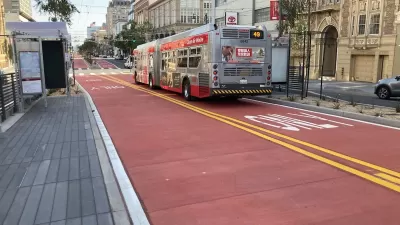
The Van Ness Avenue Bus Rapid Transit project will bring the first dedicated BRT corridor to San Francisco, nearly two decades after voters approved the project.

The San Francisco Municipal Transportation Agency (SFMTA) Muni and Golden Gate Transit recently conducted testing for the Van Ness Bus Rapid Transit (BRT) corridor, according to an article in Mass Transit. "The testing included emergency turns and maneuvers, repositioning buses, verifying signals are working, clearances between passing buses and safe turns while bike racks are deployed." Traffic engineers also tested traffic and transit signals and reviewed street markings for any needed adjustments. Staff will be trained to drive buses on a BRT line, a skill new to most Muni operators. Officials say the BRT line and associated improvements will reduce congestion and improve the speed and reliability of bus travel on Van Ness Avenue.
Last November, an article by Carl Nolte outlined the long history of Van Ness Avenue as one of San Francisco's major thoroughfares, a "grand boulevard" that later became the city's Auto Row. Today, the street serves as a major north-south arterial. The Van Ness line, San Francisco's first BRT corridor, is scheduled to open this spring after almost two decades of delays. Initially approved by voters in 2003, the project did not break ground until 2016. As stated by SFMTA, "The planned improvements are expected to cut travel times for Golden Gate Transit and the 47, 49 and 90 Muni routes by 32 percent."
FULL STORY: Bus testing on the new Van Ness BRT corridor a success

Van Ness BRT Speeds Travel by 36%, Earns Silver Designation
The San Francisco rapid bus line is making transit on the corridor more reliable and reducing traffic crashes and congestion.
Beleaguered San Francisco Bus Project To Open April 1
San Francisco's much-delayed Van Ness BRT line, expected to speed up travel along the 'grandest boulevard,' has finally received an opening date.

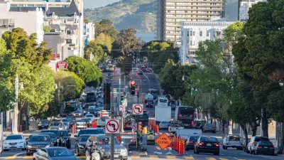
FHWA Greenlights More Red Lanes for Buses in San Francisco
The Federal Highway Administration approved 50 applications of red transit-only lanes to be painted throughout San Francisco. Already used on four streets in a pilot program, the lanes have proven effective but are opposed by some business owners.

Montreal Mall to Become 6,000 Housing Units
Place Versailles will be transformed into a mixed-use complex over the next 25 years.

Planetizen Federal Action Tracker
A weekly monitor of how Trump’s orders and actions are impacting planners and planning in America.

DARTSpace Platform Streamlines Dallas TOD Application Process
The Dallas transit agency hopes a shorter permitting timeline will boost transit-oriented development around rail stations.

Interactive Map Reveals America's “Shade Deserts”
Launched by UCLA and American Forests to combat heat-related deaths, the tool maps the shade infrastructure for over 360 U.S. cities.

Bicycles and Books — In Sacramento, Libraries Now Offer Both
Adult library card holders can check out e-bikes and e-trikes for up to one week.

Colorado Landfills Emit as Much Pollution as 1M Cars
Landfills are the third-largest source of methane pollution in Colorado, after agriculture and fossil fuel extraction.
Urban Design for Planners 1: Software Tools
This six-course series explores essential urban design concepts using open source software and equips planners with the tools they need to participate fully in the urban design process.
Planning for Universal Design
Learn the tools for implementing Universal Design in planning regulations.
City of Mt Shasta
City of Camden Redevelopment Agency
City of Astoria
Transportation Research & Education Center (TREC) at Portland State University
US High Speed Rail Association
City of Camden Redevelopment Agency
Municipality of Princeton (NJ)