


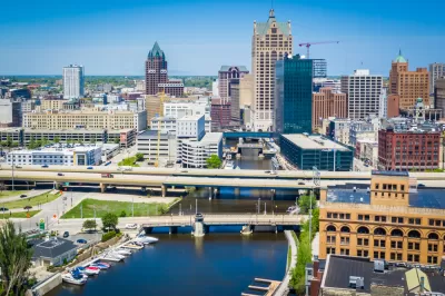
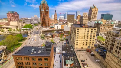
A new plan for Milwaukee's downtown will build on a "major renaissance" in the area since the approval of the last version of the plan in 2010.
Jeramey Jannene provides an update on the process of creating a new Downtown Area Plan for Milwaukee—a process launched in March 2021 to update the previous plan, approved in 2010.
The Department of City Development is partnering with Milwaukee Downtown and the Business Improvement District #21 to create the Downtown Area Plan, now known as Connec+ing MKE 2040. Jannene's coverage of the story at the end of August shared news that Milwaukee-based P3 Development Group will manage equity and engagement in the process, and Milwaukee-based The Kubala Washatko Architects will provide urban design services, along with HNTB, American Design, Inc., and raSmith.
Jannene provides additional details about the contracts and funding necessary to complete the Downtown Area Plan, and also provides an update on the major projects proposed in previous iterations of the Downtown Area Plan.
"The 2010 plan called for eight catalytic projects, four of which have been implemented or are well underway," according to Jannene. "The city and partners have successfully created a streetcar system, reactivated W. Wisconsin Ave., improved the connection between Downtown and the Historic Third Ward along N. Broadway and strategized for the creation of a Lakefront Gateway district, once The Couture is completed, near E. Michigan St. and N. Lincoln Memorial Dr."
FULL STORY: Consulting Team Announced for New Downtown Plan

Downtown Milwaukee Area Plan Update Kicks Off
Billions of dollars in investment and thousands of new residential units later, Milwaukee is ready to update the plan for its downtown.
The Once-in-a-Generation Opportunity to Remake Downtown
Urban cores around the country were transforming into live, work, and play destinations before the pandemic. The pandemic was a setback for this transformation, but it could also be a rare opportunity. It’s up to city leadership to seize it.

With 2020 Democratic National Congress on the Way, Downtown Milwaukee Revitalizes
Downtown Milwaukee is getting makeover, from high-profile new buildings on the skyline to ambitious adaptive reuse projects and an emerging entertainment district.

Maui's Vacation Rental Debate Turns Ugly
Verbal attacks, misinformation campaigns and fistfights plague a high-stakes debate to convert thousands of vacation rentals into long-term housing.

Planetizen Federal Action Tracker
A weekly monitor of how Trump’s orders and actions are impacting planners and planning in America.

San Francisco Suspends Traffic Calming Amidst Record Deaths
Citing “a challenging fiscal landscape,” the city will cease the program on the heels of 42 traffic deaths, including 24 pedestrians.

Adaptive Reuse Will Create Housing in a Suburban Texas Strip Mall
A developer is reimagining a strip mall property as a mixed-use complex with housing and retail.

Study: Anti-Homelessness Laws Don’t Work
Research shows that punitive measures that criminalized unhoused people don’t help reduce homelessness.

In U.S., Urban Gondolas Face Uphill Battle
Cities in Latin America and Europe have embraced aerial transitways — AKA gondolas — as sustainable, convenient urban transport, especially in tricky geographies. American cities have yet to catch up.
Urban Design for Planners 1: Software Tools
This six-course series explores essential urban design concepts using open source software and equips planners with the tools they need to participate fully in the urban design process.
Planning for Universal Design
Learn the tools for implementing Universal Design in planning regulations.
Heyer Gruel & Associates PA
JM Goldson LLC
Custer County Colorado
City of Camden Redevelopment Agency
City of Astoria
Transportation Research & Education Center (TREC) at Portland State University
Jefferson Parish Government
Camden Redevelopment Agency
City of Claremont