


A $26.2 billion proposal to protect the coastal area around Galveston has evolved since its first iteration in 2018.
"The Army Corps of Engineers has released the second draft of proposed coastal barrier that would fundamentally alter the southeast Texas coastline, with massive sea gates across the Houston Ship Channel and 43 miles of dunes and renourished beaches spanning Bolivar Peninsula and Galveston," reports Nick Powell.
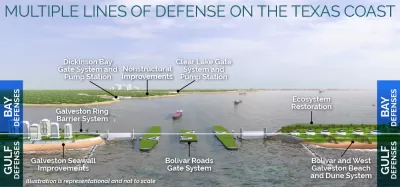
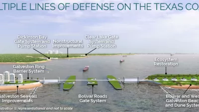
The Army Corps of Engineers selected a final version of the plan from four alternatives almost exactly two years ago. The project is designed to protect the coast of Texas in and around Galveston from a storm surge like the one that hit the area during Hurricane Ike in 2008. Among the big components of the project is a gate across the mouth of Galveston Bay and the Houston Ship Channel, according to Powell. "The gate would remain open year-round and would only be closed when a storm-surge event threatens the Texas coast or for annual maintenance checks and inspections," explains Powell. A ring levee protecting the north side of Galveston Island would also be connected to the Galveston Seawall.
The project, formerly referred to as the "Ike Dike," has undergone significant changes since its previous version: The gate would restrict tidal flow from the bay to the Gulf of Mexico by 10 percent rather than the originally proposed 27 percent. The price has also been lowered from an estimated $32 billion to the new cost of $26.2 billion, reports Powell. Since October 2018, the plan has also overcome some of the local opposition, on environmental grounds, to the plan after a series of hurricanes passed near the area this year alone and as the plan has been revised.
Now the plan will begin a public engagement process that will last until December 14. To help present the plan to the public, the Army Corps of Engineers has released interactive web features including 3-D virtual tours.
FULL STORY: Revised ‘Ike Dike’ plan would cost $26.2B, include massive sea gates and 43 miles of sand dunes

$31 Billion Hurricane Protection Plan Proposed for Texas
The U.S. Army Corps of Engineers has proposed a suite of coastal infrastructure projects—i.e., floodgates and seawalls—to shore up the coast of Texas against Hurricane- and sea level rise-aided water.
$31 Billion ‘Ike Dike’ Hurricane Protection Project Moving Through Congress
Congress authorized the $31 billion ‘Ike Dike’ sea-level rise adaptation project, along with a laundry list of other water infrastructure projects.
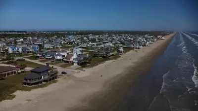
Looking for a Beach House? Check Your Risk First.
A new report from the insurance industry names the historic town of Galveston, Texas as the riskiest place to buy a beach house in the United States.

Maui's Vacation Rental Debate Turns Ugly
Verbal attacks, misinformation campaigns and fistfights plague a high-stakes debate to convert thousands of vacation rentals into long-term housing.

Planetizen Federal Action Tracker
A weekly monitor of how Trump’s orders and actions are impacting planners and planning in America.

San Francisco Suspends Traffic Calming Amidst Record Deaths
Citing “a challenging fiscal landscape,” the city will cease the program on the heels of 42 traffic deaths, including 24 pedestrians.

Defunct Pittsburgh Power Plant to Become Residential Tower
A decommissioned steam heat plant will be redeveloped into almost 100 affordable housing units.

Trump Prompts Restructuring of Transportation Research Board in “Unprecedented Overreach”
The TRB has eliminated more than half of its committees including those focused on climate, equity, and cities.

Amtrak Rolls Out New Orleans to Alabama “Mardi Gras” Train
The new service will operate morning and evening departures between Mobile and New Orleans.
Urban Design for Planners 1: Software Tools
This six-course series explores essential urban design concepts using open source software and equips planners with the tools they need to participate fully in the urban design process.
Planning for Universal Design
Learn the tools for implementing Universal Design in planning regulations.
Heyer Gruel & Associates PA
JM Goldson LLC
Custer County Colorado
City of Camden Redevelopment Agency
City of Astoria
Transportation Research & Education Center (TREC) at Portland State University
Jefferson Parish Government
Camden Redevelopment Agency
City of Claremont