


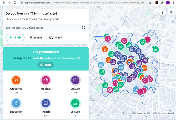
The new 15-Minute City App generates maps which show the number of services and activities within a 15 minute walk, and and therefore whether an area can be considered a 15-minute neighborhood.
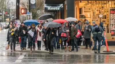
A 15-min city, or “la ville du quart d’heure” refers to an urban neighborhood where all the essential needs can be accessed within a 15 minute walk or bike ride. This is a practical way to evaluate multi-modal accessibility, that is, the ease of living without a car, and therefore whether a neighborhood is affordable, equitable, healthy and resource-efficient.
The new 15-Minute City App generates maps for U.S. addresses which show the number of medical centers, grocery stores, cultural attractions, transit stops, education facilities and leisure spots that can be reached within a 15 or 20 minute walk, and therefore whether it can be considered to be in a 15-minute neighborhood.
Real estate agents and developers pay attention: consumer preference surveys indicate that most households want to live in walkable neighborhoods, resulting in a shortage of such housing. Let's build lots more!
FULL STORY: Do you live in a “15-minute” city?


Analyzing Accessibility Disparities
With better planning we can reduce disparities between drivers and non-drivers in their ability to access services and jobs, improving fairness and economic opportunities for disadvantaged groups.
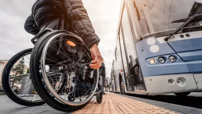
Commentary: Avoiding Ableism in 15-Minute Cities
One author calls on planners to challenge assumptions that exclude people with mobility challenges and other disabilities.

What the ‘Walk Score’ Misses
A popular walkability assessment omits key factors that impact different demographics and can direct development resources to already wealthy neighborhoods.

Planetizen Federal Action Tracker
A weekly monitor of how Trump’s orders and actions are impacting planners and planning in America.

Congressman Proposes Bill to Rename DC Metro “Trump Train”
The Make Autorail Great Again Act would withhold federal funding to the system until the Washington Metropolitan Area Transit Authority (WMATA), rebrands as the Washington Metropolitan Authority for Greater Access (WMAGA).

The Simple Legislative Tool Transforming Vacant Downtowns
In California, Michigan and Georgia, an easy win is bringing dollars — and delight — back to city centers.

The States Losing Rural Delivery Rooms at an Alarming Pace
In some states, as few as 9% of rural hospitals still deliver babies. As a result, rising pre-term births, no adequate pre-term care and harrowing close calls are a growing reality.

The Small South Asian Republic Going all in on EVs
Thanks to one simple policy change less than five years ago, 65% of new cars in this Himalayan country are now electric.

DC Backpedals on Bike Lane Protection, Swaps Barriers for Paint
Citing aesthetic concerns, the city is removing the concrete barriers and flexposts that once separated Arizona Avenue cyclists from motor vehicles.
Urban Design for Planners 1: Software Tools
This six-course series explores essential urban design concepts using open source software and equips planners with the tools they need to participate fully in the urban design process.
Planning for Universal Design
Learn the tools for implementing Universal Design in planning regulations.
Smith Gee Studio
City of Charlotte
City of Camden Redevelopment Agency
City of Astoria
Transportation Research & Education Center (TREC) at Portland State University
US High Speed Rail Association
City of Camden Redevelopment Agency
Municipality of Princeton (NJ)