


A road project in Boston involves removing hundreds of mature trees. Residents say the plan is an environmental justice issue.

A plan for a complete streets redesign of a roadway in the Roxbury neighborhood of Boston includes wider sidewalks, bike lanes, and improved bus stops. But it also involves cutting down scores of trees that run along the boulevard and could eventually threaten up to 500 mature trees.
"The rows of oaks, lindens, maples, and other trees that line Melnea Cass Boulevard in Roxbury have for decades provided vital shade, fresh air, and a leafy balance to a city corridor that can feel like a furnace in summer and a windswept tarmac in winter," reports David Abel.
More than 90 percent of Roxbury’s residents are people of color, and critics of the plan say that the trees provide essential shade and cover in an area experiencing extreme heat. They argue that removing the trees amounts to environmental racism.
The city says removal of the trees is necessary for the design of the road. A plan to replant in the area would replace the trees, but the saplings could take decades to reach maturity.
"Given the steadily rising temperatures from global warming — last month was tied for the second hottest July on record, following July 2019, the hottest month on record — critics of the project said the city should revise the construction plan to preserve far more trees," notes Abel.
FULL STORY: Alleging ‘environmental racism,’ residents protest plan to remove scores of mature trees in Roxbury

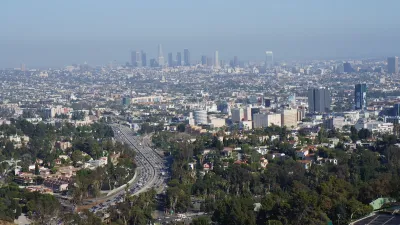
Updating LA’s Tree Rules Could Bring More Shade to Underserved Neighborhoods
A new USC study finds that relaxing Los Angeles’ outdated tree planting guidelines could significantly expand urban tree canopy and reduce shade disparities in lower-income neighborhoods, though infrastructure investments are also needed.
Mapping Heat Inequality
A new mapping tool underscores inequities in infrastructure that lead to higher rates of heat-related illnesses in low-income neighborhoods.
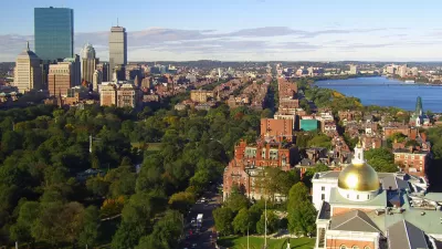
Boston Launches a 20-Year Urban Forestry Plan
The forthcoming Boston Urban Forestry Plan is expected to support communities that have been disproportionately exposed to environmental stressors.

Planetizen Federal Action Tracker
A weekly monitor of how Trump’s orders and actions are impacting planners and planning in America.

Congressman Proposes Bill to Rename DC Metro “Trump Train”
The Make Autorail Great Again Act would withhold federal funding to the system until the Washington Metropolitan Area Transit Authority (WMATA), rebrands as the Washington Metropolitan Authority for Greater Access (WMAGA).

DARTSpace Platform Streamlines Dallas TOD Application Process
The Dallas transit agency hopes a shorter permitting timeline will boost transit-oriented development around rail stations.

Parks: Essential Community Infrastructure — and a Smart Investment
Even during times of budget constraint, continued investment in parks is critical, as they provide proven benefits to public health, safety, climate resilience, and community well-being — particularly for under-resourced communities.

Porches, Pets, and the People We Grow Old With
Neighborhood connections and animal companions matter to aging with dignity, and how we build can support them. Here’s a human-scale proposal for aging in place.

Single-Stair Design Contest Envisions Human-Scale Buildings
Single-stair building construction is having a resurgence in the United States, where, for the last several decades, zoning codes have required more than one staircase in multi-story housing developments.
Urban Design for Planners 1: Software Tools
This six-course series explores essential urban design concepts using open source software and equips planners with the tools they need to participate fully in the urban design process.
Planning for Universal Design
Learn the tools for implementing Universal Design in planning regulations.
City of Charlotte
Municipality of Princeton
City of Camden Redevelopment Agency
City of Astoria
Transportation Research & Education Center (TREC) at Portland State University
US High Speed Rail Association
City of Camden Redevelopment Agency
Municipality of Princeton (NJ)