


Knowing is half the battle, and most people have a lot to learn about metropolitan planning organizations (MPOs) and how they maintain the status quo of transportation planning and spending in the United States.
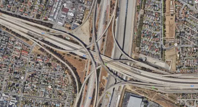
With over 400 MPOs in the United States, why have so few Americans interacted with, or understand, these organizations, even as this lack of understanding contributes to a status quo that is draining governments of money and locking in the car-centric status quo.
A blog post by Sam Sklar attempts the impossible (we kid): to explain metropolitan planning organizations, even making it sound simple:
Chances are you’ve never had a meaningful interaction with your regional transportation planning body, sometimes known as an MPO—Metropolitan Planning Organization. This organization, required by law for regions over 50,000 people, does two things: creates and maintains a long range plan (LRP) and the capital spending program that feeds into the statewide program—the Transportation Improvement Program (TIP) to the Statewide Transportation Improvement Program (STIP) superhighway.
The article provides a brief history of MPOs—even with 400 MPOs in the country, none of them have been around for that long, and the first was created in 1960. But in that time, MPOs have had an underappreciated effect on the practice of planning. Or, as Sklar puts it: "The formalization of MPOs in the early 1970s into replicable agencies exploded the rationality of planning and appropriating the future of highway dollars, now coming in the billions annually."
But the planning choices of MPOs led to freeway revolts and Sklar notes some fundamental discrepancies and conflicts with the way MPOs function, and the results they deliver.
With the many challenges of regional transportation and land use planning governance in mind, Sklar also presents a series of policy prescriptions to hold MPOS accountable for their decisions and to better deliver projects that meet the actual needs of the community. Underlying these prescriptions is an acknowledgement that large transportation projects should refocus their efforts to fixing existing infrastructure first, before expanding the capacity of the system.
FULL STORY: I'm sorry, I don't speak MPO.


Equitable Transportation Planning Initiative Advances in Northeast Ohio
The Northeast Ohio Areawide Coordinating Agency (NOACA) is moving forward with a groundbreaking policy to consider regional economic inequities when evaluating potential highway projects.
New Layer of Equity Analysis Considered for Regional Planning in Northeast Ohio
The Northeast Ohio Areawide Coordinating Agency (NOACA) is considering a new policy that will add considerations about regional economic inequities when evaluating potential highway projects.

Transportation Plan Approved for D.C. Region
Visualize 2045 makes plans for 600 projects totaling $291 billion in investments—there's some serious "blue sky" planning here.

Maui's Vacation Rental Debate Turns Ugly
Verbal attacks, misinformation campaigns and fistfights plague a high-stakes debate to convert thousands of vacation rentals into long-term housing.

Planetizen Federal Action Tracker
A weekly monitor of how Trump’s orders and actions are impacting planners and planning in America.

In Urban Planning, AI Prompting Could be the New Design Thinking
Creativity has long been key to great urban design. What if we see AI as our new creative partner?

King County Supportive Housing Program Offers Hope for Unhoused Residents
The county is taking a ‘Housing First’ approach that prioritizes getting people into housing, then offering wraparound supportive services.

Researchers Use AI to Get Clearer Picture of US Housing
Analysts are using artificial intelligence to supercharge their research by allowing them to comb through data faster. Though these AI tools can be error prone, they save time and housing researchers are optimistic about the future.

Making Shared Micromobility More Inclusive
Cities and shared mobility system operators can do more to include people with disabilities in planning and operations, per a new report.
Urban Design for Planners 1: Software Tools
This six-course series explores essential urban design concepts using open source software and equips planners with the tools they need to participate fully in the urban design process.
Planning for Universal Design
Learn the tools for implementing Universal Design in planning regulations.
planning NEXT
Appalachian Highlands Housing Partners
Mpact (founded as Rail~Volution)
City of Camden Redevelopment Agency
City of Astoria
City of Portland
City of Laramie