


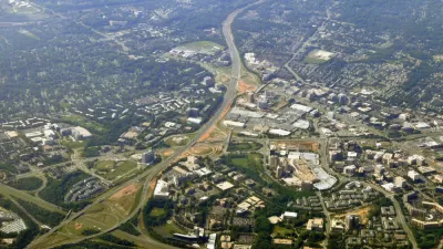
Ten years after Tysons, an unincorporated community in Fairfax County, Virginia, approved an award winning comprehensive plan, there's still work to be done to achieve its ambitious goals.
Emily Hamilton, a research fellow and director of the Mercatus Center at George Mason University’s Urbanity Project, checks in with the status of the transformation of Tysons ten years after the city adopted a comprehensive plan to take advantage of the arrival of light rail transit and a growing residential population in this corner of Fairfax County of Northern Virginia.
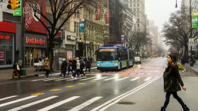
According to Hamilton's assessment, Tysons has work to do to achieve the goals set forth in the plan. "The plan was heralded by the American Planning Association for seeking to transform a sprawling, highway-oriented area into a series of transit-oriented, walkable neighborhoods. So far, for all its progress, it has not ushered in an era of easy walkability," according to Hamilton. (The Tysons Comprehensive Plan earned the 2011 Daniel Burnham Award for a Comprehensive Plan from the American Planning Association.)
This is the second article by Hamilton evaluating the progress of the Tysons Comprehensive Plan. In the first article, Hamilton focused on the effect on walkability from the wave of new residential development in Tysons since 2010. This latest article focuses on the transportation planning choices that have limited the success of the plan:
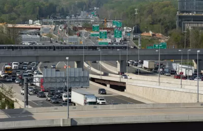
A freeway and multiple major arterial roads cut through Tysons. The comprehensive plan calls for slowing cars down and transforming the arterials into tree-lined boulevards with wide sidewalks and medians that would make them safe for pedestrians.
At the same time, the plan promised to maintain commute times for drivers going to or through Tysons. To this end, policymakers have actually widened some Tysons arterials rather than making major improvements to them for walkers. To cross parts of Route 123, walkers have to traverse 12 lanes of traffic.
Still, according to Hamilton, the Tysons Comprehensive Plan was set up to succeed, and it's still possible to achieve all of the ambitious goals included in the plan.
FULL STORY: Ten years into redevelopment, is Tysons what we envisioned?

Survey Says New Yorker Want More Protected Bike and Bus Lanes, Less Parking
A new survey reveals broad support for a less car-centric approach to capital investment in the city of New York.
The Great Retrofit: Transforming Tysons With Walkable Residential Development
A 2010 comprehensive plan set a goal to add 100,000 residential units with walkable access to public transit to this unincorporated corner of Fairfax County in Northern Virginia.
‘Stroads:’ The Worst of Both Worlds
An urban planning critic says the U.S. should build streets for people to live on, and roads to move traffic quickly.

Maui's Vacation Rental Debate Turns Ugly
Verbal attacks, misinformation campaigns and fistfights plague a high-stakes debate to convert thousands of vacation rentals into long-term housing.

Planetizen Federal Action Tracker
A weekly monitor of how Trump’s orders and actions are impacting planners and planning in America.

In Urban Planning, AI Prompting Could be the New Design Thinking
Creativity has long been key to great urban design. What if we see AI as our new creative partner?

King County Supportive Housing Program Offers Hope for Unhoused Residents
The county is taking a ‘Housing First’ approach that prioritizes getting people into housing, then offering wraparound supportive services.

Researchers Use AI to Get Clearer Picture of US Housing
Analysts are using artificial intelligence to supercharge their research by allowing them to comb through data faster. Though these AI tools can be error prone, they save time and housing researchers are optimistic about the future.

Making Shared Micromobility More Inclusive
Cities and shared mobility system operators can do more to include people with disabilities in planning and operations, per a new report.
Urban Design for Planners 1: Software Tools
This six-course series explores essential urban design concepts using open source software and equips planners with the tools they need to participate fully in the urban design process.
Planning for Universal Design
Learn the tools for implementing Universal Design in planning regulations.
planning NEXT
Appalachian Highlands Housing Partners
Mpact (founded as Rail~Volution)
City of Camden Redevelopment Agency
City of Astoria
City of Portland
City of Laramie