


Big data startups and corporations are collecting information that can help planners make informed decisions about how to facilitate social distancing. Will planners center data-driven decisions in other planning processes?
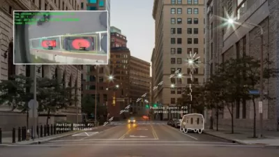
The conversation around the relationship between big data and urban planning is changing as a result of the coronavirus pandemic, writes Rob Walker. One company, Numina, has long been collecting data tracking pedestrians, cyclists, and other street-level travelers. Their data now has larger, far-reaching implications for mobility during the pandemic, in adding to "a public discussion in multiple cities about closing streets to give walkers and cyclists more space to move safely," according to Walker.
As new uses for big data prove helpful for reanalyzing public spaces, many argue that it could inform other aspects of the planning process by giving concrete answers to questions about how people behave and allowing planners to predict future behavior related to new plan implementation. "What if neutral data could suggest different answers to, say, where that new bridge should go, or which buildings to target for preservation? Answers based not on selective feedback, but on evidence that is already being collected by tech companies?" Walker queries. If tech companies can work to resolve concerns about privacy, policymakers and planners could use new data sources to inform a plethora of important decisions.
FULL STORY: Data Companies Track Our Pandemic Patterns


Regulatory Considerations for Online Public Engagement: Ensuring the Viability of Projects
As online engagement becomes increasingly important during COVID-19, so does understanding compliance with legal requirements.
Equity and 'Righting Past Wrongs' to Start the 2021 National Planning Conference
The American Planning Association's 2021 National Planning Conference started streaming this morning, with an obvious focus on equity and the historical role of the planning profession in perpetuating systemic racism.

Pre-Existing Conditions
Vital urbanism and a prescription for the post-pandemic city.

Planetizen Federal Action Tracker
A weekly monitor of how Trump’s orders and actions are impacting planners and planning in America.

Chicago’s Ghost Rails
Just beneath the surface of the modern city lie the remnants of its expansive early 20th-century streetcar system.

San Antonio and Austin are Fusing Into one Massive Megaregion
The region spanning the two central Texas cities is growing fast, posing challenges for local infrastructure and water supplies.

Since Zion's Shuttles Went Electric “The Smog is Gone”
Visitors to Zion National Park can enjoy the canyon via the nation’s first fully electric park shuttle system.

Trump Distributing DOT Safety Funds at 1/10 Rate of Biden
Funds for Safe Streets and other transportation safety and equity programs are being held up by administrative reviews and conflicts with the Trump administration’s priorities.

German Cities Subsidize Taxis for Women Amid Wave of Violence
Free or low-cost taxi rides can help women navigate cities more safely, but critics say the programs don't address the root causes of violence against women.
Urban Design for Planners 1: Software Tools
This six-course series explores essential urban design concepts using open source software and equips planners with the tools they need to participate fully in the urban design process.
Planning for Universal Design
Learn the tools for implementing Universal Design in planning regulations.
planning NEXT
Appalachian Highlands Housing Partners
Mpact (founded as Rail~Volution)
City of Camden Redevelopment Agency
City of Astoria
City of Portland
City of Laramie