


Faced with the task of rethinking its transportation systems in the face of the ongoing public health crisis, Paris and the Île-de-France are clearing the way for people on bikes.
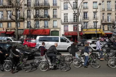
"Paris is the latest global city to roll out emergency bike lanes for the use of key workers and others during the lockdown," according to an article by Carlton Reid. The shift toward bike priority in Paris will last beyond the lockdown.
Concerns about transportation mode choices (i.e., a massive shift to automobile trips) after the lockdown has led Paris Mayor Anne Hidalgo ready 650 kilometers of cycleways—including "corona cycleways"—for May 11 when the lockdown is eased in France. Mayor Hidalgo is also accelerating the existing "Plan Vélo," which is designed to turn Paris into a 15-minute city. A January 2020 article by Reid reported in more detail about Mayor Hidalgo's ambitious plans to end the car-centric design of Paris streets.
Now, Mayor Hidalgo's efforts have support from higher levels of government. "On April 21, the Île-de-France region pledged financial support for the preexisting RER Vélo project, a network of nine protected cycleways linking the center of Paris with key suburbs, a concept of the Ile-de-France Bike Collective advocacy network," reports Reid. "€300 million will be provided to part-pay for a mix of new infrastructure and temporary 'corona cycleways,' or TempoRER vélo," according to Reid.
FULL STORY: Paris To Create 650 Kilometers Of Post-Lockdown Cycleways

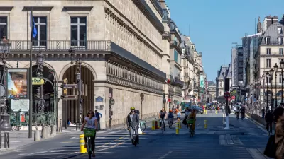
Paris Plans to Become a '100 Percent Cyclable' City
Mayor Anne Hidalgo continues her commitment to making Paris more bikeable with a new plan that will improve bike parking and facilities in the French capital.
The Car-Free Revolution Continues in Paris
The city continues to reclaim space for pedestrians and cyclists.

Lockdown Benefits Urban Farmers In Paris
Pandemic induced lockdown kept Parisians within 1 km of their homes during lockdown, benefiting urban farmers and advocates for a diversified local food supply.

Planetizen Federal Action Tracker
A weekly monitor of how Trump’s orders and actions are impacting planners and planning in America.

Congressman Proposes Bill to Rename DC Metro “Trump Train”
The Make Autorail Great Again Act would withhold federal funding to the system until the Washington Metropolitan Area Transit Authority (WMATA), rebrands as the Washington Metropolitan Authority for Greater Access (WMAGA).

DARTSpace Platform Streamlines Dallas TOD Application Process
The Dallas transit agency hopes a shorter permitting timeline will boost transit-oriented development around rail stations.

Maryland Plans Quick-Build Complete Streets Projects
The state will use low-cost interventions to improve road safety in five Maryland counties.

Downtown Los Angeles Gears Up for Growth
A new report highlights Downtown L.A.’s ongoing revival through major housing projects, adaptive reuse, hospitality growth, and preparations for global events in the years ahead.

Supreme Court Landlord Appeal Case Could Overturn Tenant Protections
A legal case claiming that COVID-era eviction moratoriums were unconstitutional could spell trouble for tenant protections.
Urban Design for Planners 1: Software Tools
This six-course series explores essential urban design concepts using open source software and equips planners with the tools they need to participate fully in the urban design process.
Planning for Universal Design
Learn the tools for implementing Universal Design in planning regulations.
Municipality of Princeton
Roanoke Valley-Alleghany Regional Commission
City of Mt Shasta
City of Camden Redevelopment Agency
City of Astoria
Transportation Research & Education Center (TREC) at Portland State University
US High Speed Rail Association
City of Camden Redevelopment Agency
Municipality of Princeton (NJ)