


A new mapping project from researchers at the University of Pennsylvania illustrates the consequences of inaction on climate change.

Sarah Holder shares the work of researchers at the McHarg Center for Urban Ecology at the University of Pennsylvania to map the expected effects of climate change in the United States, calling it the 2100 Project: An Atlas for a Green New Deal.
"The website use a variety of projected and current data sources to sketch out the country’s possible fate, displaying its geography in economic, ecological, agricultural, and ideological terms," explains Holder.
Billy Fleming, the director of the McHarg Center, is quoted in the article saying that the project proves that it’s not to late to make a fundamental difference in the losses the country will experience as the effects of climate change take shape.
The article includes a few examples of maps from the project, on subjects like annual average temperature, mortality, economic effects, and more.
FULL STORY: America After Climate Change, Mapped

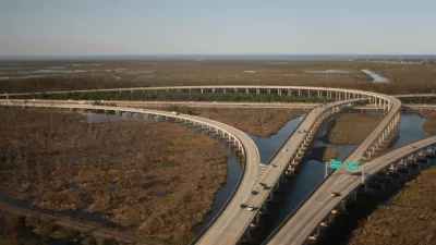
$50 Billion Coastal Master Plan Updated in Louisiana
Louisiana is losing coastal lands, quickly, along with the habitat and economic resources located there. A Coastal Master Plan plots $50 billion in spending to protect the coast.

Climate Change: The Most Vulnerable States Are the Least Prepared
The effects of climate change will vary depending on geographic location, so it's incumbent on states to prepare in their own, specific way. Not all states are taking that responsibility seriously, according to a new report.

Town Hall Spotlights Democrats' Climate Change Proposals
Critics of the earliest Democratic candidate debates have noted a conspicuous lack of substantive and concentrated discussion on one of the great existential threats of the era: climate change. Neglect of the subject could change soon.

Planetizen Federal Action Tracker
A weekly monitor of how Trump’s orders and actions are impacting planners and planning in America.

Congressman Proposes Bill to Rename DC Metro “Trump Train”
The Make Autorail Great Again Act would withhold federal funding to the system until the Washington Metropolitan Area Transit Authority (WMATA), rebrands as the Washington Metropolitan Authority for Greater Access (WMAGA).

The Simple Legislative Tool Transforming Vacant Downtowns
In California, Michigan and Georgia, an easy win is bringing dollars — and delight — back to city centers.

The States Losing Rural Delivery Rooms at an Alarming Pace
In some states, as few as 9% of rural hospitals still deliver babies. As a result, rising pre-term births, no adequate pre-term care and harrowing close calls are a growing reality.

The Small South Asian Republic Going all in on EVs
Thanks to one simple policy change less than five years ago, 65% of new cars in this Himalayan country are now electric.

DC Backpedals on Bike Lane Protection, Swaps Barriers for Paint
Citing aesthetic concerns, the city is removing the concrete barriers and flexposts that once separated Arizona Avenue cyclists from motor vehicles.
Urban Design for Planners 1: Software Tools
This six-course series explores essential urban design concepts using open source software and equips planners with the tools they need to participate fully in the urban design process.
Planning for Universal Design
Learn the tools for implementing Universal Design in planning regulations.
Smith Gee Studio
City of Charlotte
City of Camden Redevelopment Agency
City of Astoria
Transportation Research & Education Center (TREC) at Portland State University
US High Speed Rail Association
City of Camden Redevelopment Agency
Municipality of Princeton (NJ)