


Louisiana is losing coastal lands, quickly, along with the habitat and economic resources located there. A Coastal Master Plan plots $50 billion in spending to protect the coast.
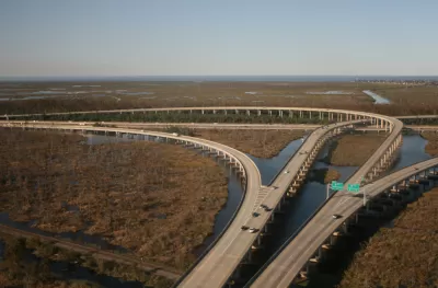
The Louisiana Coastal Protection and Restoration Authority recently released a 100-page, draft update of a $50 billion coastal master plan, officially titled the 2023 Coastal Master Plan, with several substantive changes proposed for the coming year.
Mark Schleifstein broke the news of the new plan earlier this month, reporting that the draft updated for the plan calls for 61 new projects to “to build or protect land, a dozen new levees, and new efforts to elevate, flood-proof or relocate flood-prone homes” in the plan. In all, the plan is estimated to reduce hurricane storm damages by $11 billion every year by 2073.
Among the changes included in the draft update are “construction of projects long proposed to reduce flooding risk, such as a $2.4 billion concrete barrier and weir combination aimed at reducing surge entering Lake Pontchartrain through the Rigolets and Chef Menteur passes,” according to Schleifstein. Schleifstein also reports that the draft plan reverses course on the idea of building levees, “including plans to protect portions of Iberia and St. Mary parishes from Gulf of Mexico surge; to dramatically upgrade levees surrounding the Lafitte area, and to protect portions of St. James and Ascension parishes, where sea level rise is expected to increase the threat of flooding from Lake Maurepas over the next 50 years.
As noted in the article, the Louisiana has already lost 2,000 square miles of coastal land since 1932, directly impacting fisheries and wildlife resources along the coast—along with the jobs that depend on them.
More details from the updated plan (this is the fourth update of the plan since it was first adopted by the Louisiana State legislature in 2007) are included in the source article below. Public comment on the plan is open through March 25.
FULL STORY: Louisiana's draft coastal master plan update promises billions in hurricane-damage savings


Report: Embarcadero Needs to Rise 7 Feet to Resist Sea-Level Rise
A bombshell report details the adaptation measures that will be necessary to keep San Francisco's Embarcadero high and dry as the climate changes and sea levels rise.

The Changing Risks of Coastal Communities
An excerpt from "A Blueprint for Coastal Adaptation: Uniting Design, Economics, and Policy," published in May by Island Press.

Climate Change: The Most Vulnerable States Are the Least Prepared
The effects of climate change will vary depending on geographic location, so it's incumbent on states to prepare in their own, specific way. Not all states are taking that responsibility seriously, according to a new report.

Planetizen Federal Action Tracker
A weekly monitor of how Trump’s orders and actions are impacting planners and planning in America.

Maui's Vacation Rental Debate Turns Ugly
Verbal attacks, misinformation campaigns and fistfights plague a high-stakes debate to convert thousands of vacation rentals into long-term housing.

San Francisco Suspends Traffic Calming Amidst Record Deaths
Citing “a challenging fiscal landscape,” the city will cease the program on the heels of 42 traffic deaths, including 24 pedestrians.

Amtrak Rolls Out New Orleans to Alabama “Mardi Gras” Train
The new service will operate morning and evening departures between Mobile and New Orleans.

The Subversive Car-Free Guide to Trump's Great American Road Trip
Car-free ways to access Chicagoland’s best tourist attractions.

San Antonio and Austin are Fusing Into one Massive Megaregion
The region spanning the two central Texas cities is growing fast, posing challenges for local infrastructure and water supplies.
Urban Design for Planners 1: Software Tools
This six-course series explores essential urban design concepts using open source software and equips planners with the tools they need to participate fully in the urban design process.
Planning for Universal Design
Learn the tools for implementing Universal Design in planning regulations.
Heyer Gruel & Associates PA
JM Goldson LLC
Custer County Colorado
City of Camden Redevelopment Agency
City of Astoria
Transportation Research & Education Center (TREC) at Portland State University
Jefferson Parish Government
Camden Redevelopment Agency
City of Claremont